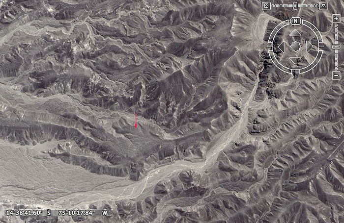
Nazca lines
Albrecht Kottmann -- Writing system
Albrecht Kottmann tried another approach to the Nazca-Mystery. He divided the figures into different parts and analyzed them in a geometrical way. So he divided a bird of 286 Meter length into 22 Parts. So he found that the head takes two parts, the neck five parts, the body three parts and the other twelve parts for the beak. The proportion between the beak and the rest is 6:5. Kottmann believes the geometric signs are a picture writing system with giant and small letters.
This type of writing system, known as "ligature writing," has been established in the Negev (Israel) desert among the proto-Canaanites and even in Colorado among the Bronze Age inhabitants near what is now La Junta. It has been documented by scholars such as William Harris (BYU). The writing often combines alphabetical shapes to form an image suggestive of the word meaning. In this way, illiterate people could understand the writing.
William H. Isbell -- provision of work
Isbell's theory is that the kings of Nazca ordered the drawing of the nazca-line to control the population. This is similar to the historical reasons for constructing the Great Wall of China . When they did work they couldn't make children. Isbell theorizes that the Nazca Indians were not able to store food and therefore population control was implemented.
Walk the line...
Viewzone recenly did an article on Ancient Labyrinths and concluded that they were "walked" as part of a mental ritual, signifying something akin to a renewal exercise or "rebirth." The animal figures in Peru seem to have been drawn using a single line or path that meanders in specific shapes, taking the walker on a sort of "journey." Although we may never fully understand what these specific animals and shapes represented to the ancients who made them, it seems likely that these figures were used for some spiritual purpose. The intellect and effort taken to make them, coupled with the repeated ritualistic use, certainly points in that direction.
Wat do you think?
Nazca Lines and Cahuachi Culture
Stretching across the Nazca plains like a giant map or blueprint left by ancient astronauts, lie the famous Nazca Lines of Peru. Peru is associated with the Inca Civilization.
The Nazca Lines are an engima. No one has proof who built them or why. Since their discovery, the Nazca Lines have inspired fantastic explanations from ancient gods, a landing strip for returning aliens, a celestial calendar created by the ancient Nazca civilization -- putting the creation of the lines between 200 BC and 600 AD, used for rituals probably related to astronomy, to confirm the ayllus or clans who made up the population and to determine through ritual their economic functions held up by reciprocity and redistribution, or a map of underground water supplies.
There are also huge geoglyphs in Egypt, Malta, United States (Mississippi and California), Chile, Bolivia and in other countries. But the Nazca geoglyphs, because of their numbers, characteristics, dimensions and cultural continuity, were made and remade throughout the whole pre-hispanic period, forming a most impressive, as well as enigmatic, archeological group.
Location
The Nazca Lines are located in the Nazca Desert, a high arid plateau that stretches between the towns of Nazca and Palpa on the pampa (a large flat area of southern Peru). The desolate plain of the Peruvian coast which comprises the Pampas of San Jose (Jumana), Socos, El Ingenio and others in the province of Nasca, is 400 Km. South of Lima, covers an area of approximately 450 km2, of sandy desert as well as the slopes of the contours of the Andes. They cover nearly 400 square miles of desert. Etched in the surface of the desert pampa sand about 300 hundred figures made of straight lines, geometric shapes most clearly visible from the air.
Nazca Plain
The Nazca plain is virtually unique for its ability to preserve the markings upon it, due to the combination of the climate (one of the driest on Earth, with only twenty minutes of rainfall per year) and the flat, stony ground which minimises the effect of the wind at ground level. With no dust or sand to cover the plain, and little rain or wind to erode it, lines drawn here tend to stay drawn. These factors, combined with the existence of a lighter-colored subsoil beneath the desert crust, provide a vast writing pad that is ideally suited to the artist who wants to leave his mark for eternity.
The pebbles which cover the surface of the desert contain ferrous oxide. The exposure of centuries has given them a dark patina. When the gravel is removed, they contrast with the color underneath. In this way the lines were drawn as furrows of a lighter color, even though in some cases they became prints. In other cases, the stones defining the lines and drawings form small lateral humps of different sizes. Some drawings, especially the early ones, were made by removing the stones and gravel from their contours and in this way the figures stood out in high relief.
The concentration and juxtaposition of the lines and drawings leave no doubt that they required intensive long-term labor as is demonstrated by the stylistic continuity of the designs, which clearly correspond to the different stages of cultural changes.
Nazca Lines - Enigmatic Designs
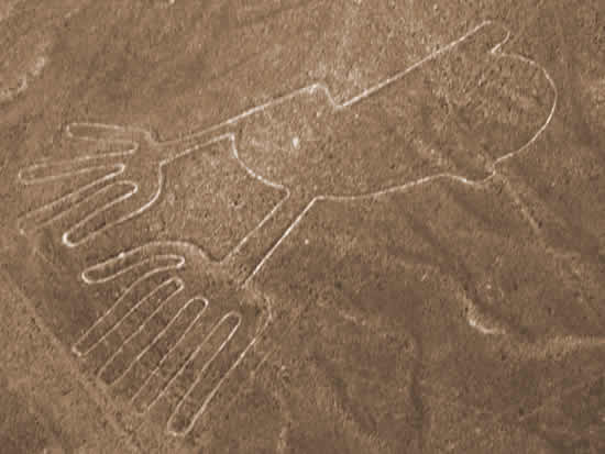
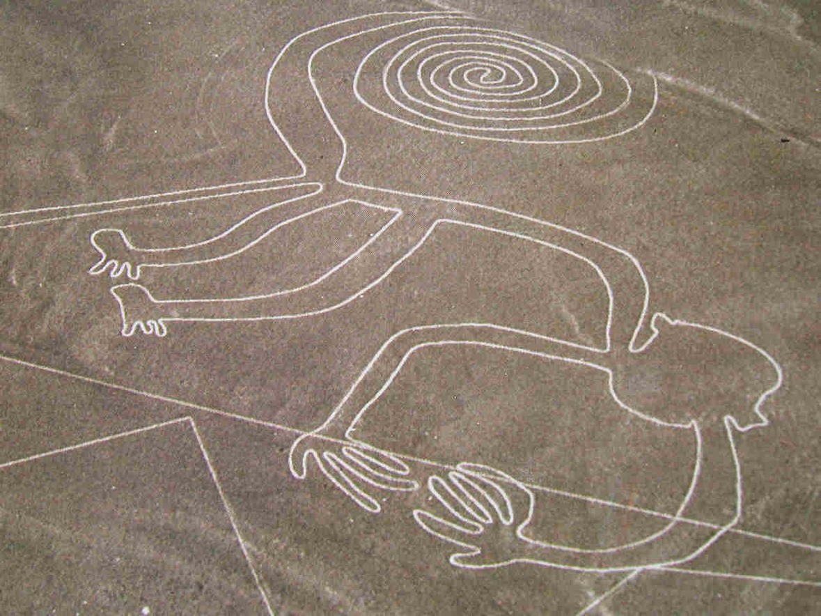
There appear to be various designs consisting of figures of animals, flowers and plants, objects, and anthropomorphic figures of colossal proportions made with well-defined lines. An example of this is the drawing of a weird being with two enormous hands, one normal and the other with only four fingers.
Also represented are drawings of man-made objects such as yarn, looms and "tupus" (ornamental clasps). All these figures have well-defined entrances which could be used as paths or to allow people to line together along the conformations of the drawings.
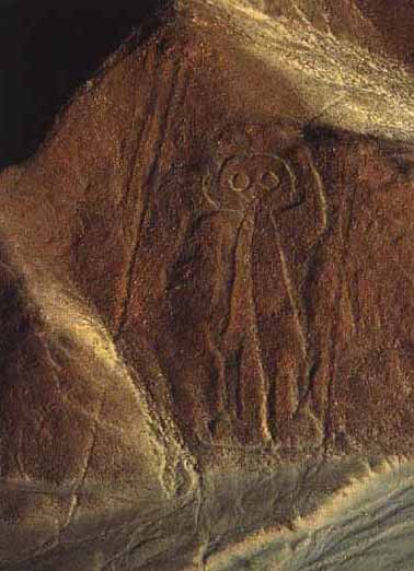
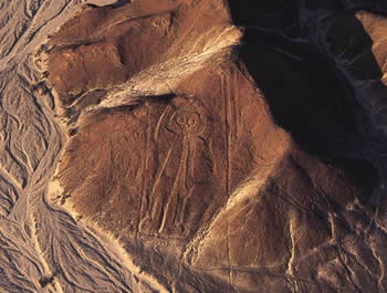
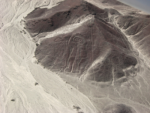
The anthropomorphic figures are relatively few and are situated on the slopes. The most well-known being is The Astronaut at 32m length discovered by Eduardo Herran in 1982.
Stretching across the Nazca plains like a giant map or blueprint left by ancient astronauts, lie the famous Nazca Lines of Peru. Peru is associated with the Inca Civilization.
The Nazca Lines are an engima. No one has proof who built them or why. Since their discovery, the Nazca Lines have inspired fantastic explanations from ancient gods, a landing strip for returning aliens, a celestial calendar created by the ancient Nazca civilization -- putting the creation of the lines between 200 BC and 600 AD, used for rituals probably related to astronomy, to confirm the ayllus or clans who made up the population and to determine through ritual their economic functions held up by reciprocity and redistribution, or a map of underground water supplies.
There are also huge geoglyphs in Egypt, Malta, United States (Mississippi and California), Chile, Bolivia and in other countries. But the Nazca geoglyphs, because of their numbers, characteristics, dimensions and cultural continuity, were made and remade throughout the whole pre-hispanic period, forming a most impressive, as well as enigmatic, archeological group.
Location
The Nazca Lines are located in the Nazca Desert, a high arid plateau that stretches between the towns of Nazca and Palpa on the pampa (a large flat area of southern Peru). The desolate plain of the Peruvian coast which comprises the Pampas of San Jose (Jumana), Socos, El Ingenio and others in the province of Nasca, is 400 Km. South of Lima, covers an area of approximately 450 km2, of sandy desert as well as the slopes of the contours of the Andes. They cover nearly 400 square miles of desert. Etched in the surface of the desert pampa sand about 300 hundred figures made of straight lines, geometric shapes most clearly visible from the air.
Nazca Plain
The Nazca plain is virtually unique for its ability to preserve the markings upon it, due to the combination of the climate (one of the driest on Earth, with only twenty minutes of rainfall per year) and the flat, stony ground which minimises the effect of the wind at ground level. With no dust or sand to cover the plain, and little rain or wind to erode it, lines drawn here tend to stay drawn. These factors, combined with the existence of a lighter-colored subsoil beneath the desert crust, provide a vast writing pad that is ideally suited to the artist who wants to leave his mark for eternity.
The pebbles which cover the surface of the desert contain ferrous oxide. The exposure of centuries has given them a dark patina. When the gravel is removed, they contrast with the color underneath. In this way the lines were drawn as furrows of a lighter color, even though in some cases they became prints. In other cases, the stones defining the lines and drawings form small lateral humps of different sizes. Some drawings, especially the early ones, were made by removing the stones and gravel from their contours and in this way the figures stood out in high relief.
The concentration and juxtaposition of the lines and drawings leave no doubt that they required intensive long-term labor as is demonstrated by the stylistic continuity of the designs, which clearly correspond to the different stages of cultural changes.
Nazca Lines - Enigmatic Designs
There appear to be various designs consisting of figures of animals, flowers and plants, objects, and anthropomorphic figures of colossal proportions made with well-defined lines. An example of this is the drawing of a weird being with two enormous hands, one normal and the other with only four fingers.
Also represented are drawings of man-made objects such as yarn, looms and "tupus" (ornamental clasps). All these figures have well-defined entrances which could be used as paths or to allow people to line together along the conformations of the drawings.
The anthropomorphic figures are relatively few and are situated on the slopes. The most well-known being is The Astronaut at 32m length discovered by Eduardo Herran in 1982.
Ancient Astronaut?
The lines are many kilometers long and crisscross sectors of the pampas in all directions. Many of the lines form geometric figures: angles, triangles, bunches, spirals, rectangles, wavy lines, concentric circles.
The lines are many kilometers long and crisscross sectors of the pampas in all directions. Many of the lines form geometric figures: angles, triangles, bunches, spirals, rectangles, wavy lines, concentric circles.
Killer Whale Odontoceti
Orcinus orca
Orcinus orca
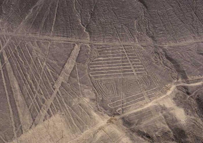
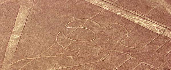
SPIRAL
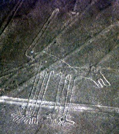
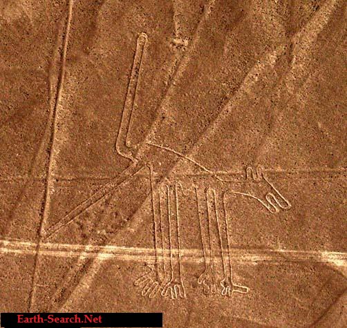
HANDS
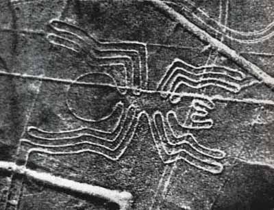
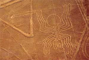
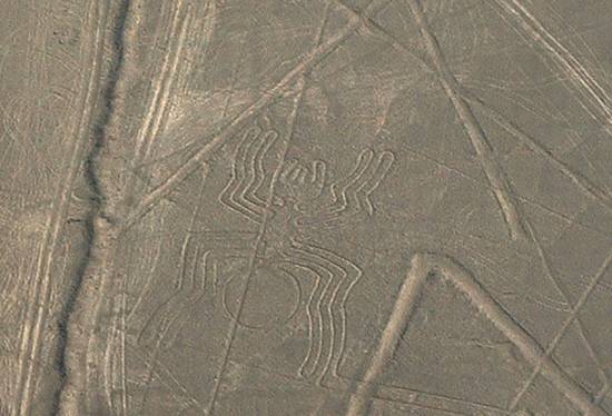
SPIDER
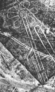
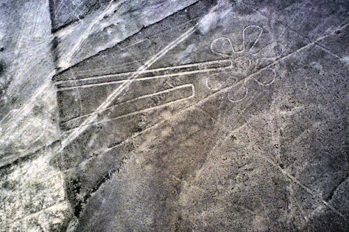
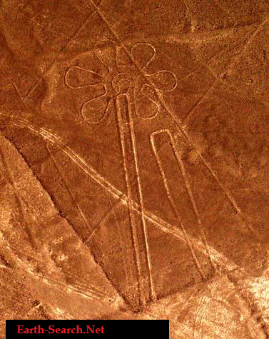
FLOWER
DOG
TRIANGLE
TRAPAZIODS
Nazca Mandala

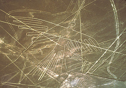
PELICAN
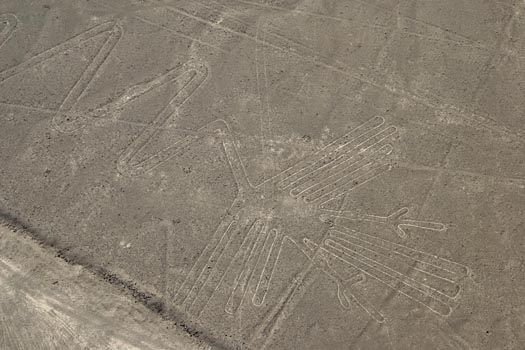
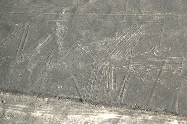
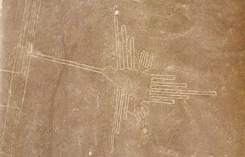
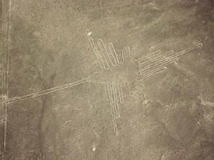
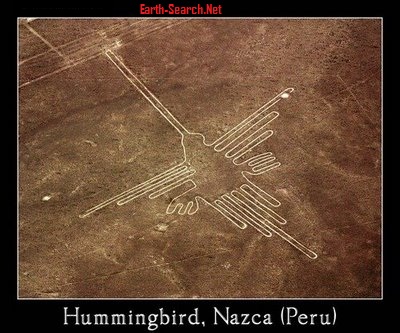
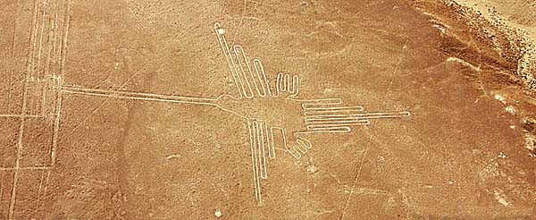
HUMMINGBIRD
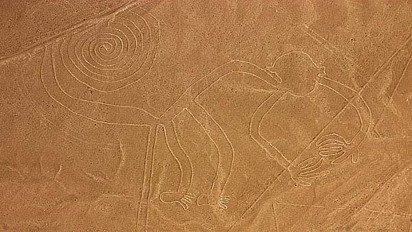
MONKEY
The Lines were allegedly made by removing the iron-oxide coated pebbles which cover the surface of the desert. When the gravel is removed, they contrast with the light color underneath. In this way the lines were drawn as furrows of a lighter color. Off the Pampa, south of the Nazca Lines, archaeologists have now uncovered the lost city of the line-builders, Cahuachi. It was built nearly 2,000 years ago and mysteriously abandoned 500 years later.
Discovering the Nazca Lines by Outsiders
The Nazca Lines were first spotted when commercial airlines began flying across the Peruvian desert in the 1920's. Passengers reported seeing 'primitive landing strips' on the ground below. Today people sometimes fly in hot air balloons to view the splendors of the Nazca Lines, their eneries awakening something within their souls.
Preserving the Nazca Lines
It is difficult to keep the Nazca Lines free from outside intervention. As with all ancient ruins, such as Machu Piccu, weather by wind and rain, and human tampering will take their toll on these ancient Lines.
In recent years the Nazca Lines have suffered gradual destruction, as tomb raiders seeking pre-Inca artifacts scar the terrain with hundreds of burrows, garbage, among other waste material. A boom in copper and gold mining - including a mine built in 1997 a few feet from a 2,000-year-old, two-mile-long trapezoid -- is defacing parts of the Nazca Lines with tracks from truck traffic.
Over the past decade, advertisers and political campaigns have carved huge messages in the rock and sand between the ancient designs in this region 250 miles south of Lima.
In 1998, floods and mudslides from the El Nino weather pattern seriously eroded several figures.
As electricity reaches the growing local population, utility companies are running power cables over and around the site.
The damage to the Lines underscores Peru's desperate struggle to preserve its national patrimony. Archaeologists say they are watching helplessly as the quest for scholarship and conservation in a country viewed as the cradle of New World civilization is losing out to commercial interests, bleak poverty and the growing popularity of heritage sites as tourist attractions.
Theories
Toribio Mejia Xespe, a Peruvian doctor and anthropologist was the first scientist, in 1927, to show interest in what he called "great Incan ceremonial artifacts".
Michael Coe believes the Nazca Lines are sacred paths to walk by specific rites. The primary lines were an offering for elders, heaven, and mountain deities who gave them water for their fields.
Erich von Daniken suggested, in his 1968 book, Chariots of the Gods, that the lines were built by ancient astronauts as a landing strip. But the soft clay soil and layer of brown and black rocks in the Nazca desert would seem an unsuitable site for landing and were blown away by the power of rocket propulsion. The aliens left - never to return - leaving the people confused. Like in the modern cargo cults they tried to call the Gods back by drawing lines, figures and trapezes.
Robin Edgar beieved that the Nazca Figures were inspired by, and intended to be seen by, the (so-called) Eye of God that is manifested during total solar eclipses. An extraordinary series of solar eclipses coincided with the construction of the Nasca lines. Some Lines are aligned with the winter solstice, a less spectacular but more regular, death and rebirth of the Sun God.
The Code of Carl Munck - The Ancient Geomatria of Numbers --The Nazca Line ground markings locate themselves on The Code Matrix system. Nazca Lines and Archaeocryptography The ancient sites around the world are very precisely positioned on a global coordinate system in relation to the position of the Great Pyramid at Giza. The positions of the sites are given in the geometry of their construction. A very ancient system of numbers was used in the system, which we will call Gematria. Gematrian numbers are found in ancient myths and religions, including the Bible. Gematrian numbers were used in systems of weights and measures by ancient peoples, including the Greeks, the Egyptians, the Persians, the Babylonians and the Romans. The Code system uses mathematical constants, such as pi and the radian. The system also uses conventions that are still in use, such as the 360 degree circle, 60 minute degree, 60 second minute, the base-ten numbering system, the 12-inch foot, and the 5280-foot mile.
The ancient Mayans used Gematrian numbers in their very accurate timekeeping.
Maria Reiche was a German mathematician and archaeologist who was famous for researching the Nazca Lines. She believed the lines were an Astronomical Calendar indicating the direction of the rising of important stars and planetary events like sun solstices. Formations like the spider and the monkey could show star constellations like Orion and Ursa Mayor. The problem with all astronomical theories is the unknowing of the age. The direction of stars changes within centuries, explained by the precession of the equinoxes.
Reiche led a determined effort to discredit theories of extraterrestrial visitors. She argued that the Nazca Indians constructed the Lines some time between 300 BC and AD 800. In support of this possibility, some scientists have put forward ingenious ideas on how the geoglyphs could theoretically have been designed from the ground. The more important evidence, however, is that which attempts to link the Lines definitively to the Nazcan culture. Here, neither of the two key pieces of evidence survive close scrutiny.
The first piece of evidence is a series of radiocarbon dates, based on ceramic and wood remains which were left at the Lines by the Nazca people. It is claimed that this proves that the Nazcans constructed the Lines. On the contrary, the dating of these materials tells us only that the Nazcans lived in the area of the Nazca Lines. Since the Lines themselves cannot be radiocarbon dated, the possibility remains that they already existed when the Nazcan culture emerged. The second piece of evidence is the alleged resemblance of the Nazca geoglyphs to certain features found on Nazca pottery. This is an important issue because it potentially offers proof that the Nazcans had either designed the images or at least viewed them from the air. Maria Reiche died in 1998 at the age of 95. She is buried in the arid valley she loved so well.
Professor Gerald Hawkins and his group went to Nazca to prove the astronomical Theory of Maria Reiche but was unsuccessful. In 1968, a study by the National Geographic Society determined that, while some of the Nazca lines did point to the positions of the Sun, Moon and certain stars two thousand years ago, it was no more than could be expected by mere chance. In 1973, Dr Gerald Hawkins studied 186 lines with a computer program and found that only 20 per cent had any astronomical orientation - again no more than by pure chance.
Simone Waisbard stated that the drawing of Nazca are a giant astronomical calendar. Further the Nazca-line-system was used to measure the precipitation value. Figures, especially seabirds, have a connection to the meteorological prophecy system of the Nazca-Culture. Her ideas for the trapezoid formations: places for holy animals before sacrifice them, or field claims connected with filter galleries, observatories or places for ritual ceremonies of the different clans.
Alan F. Alford concluded that the Nazca-Lines was made by Negroid Slaves of the Tihuanaco Culture. After a revolution the Negroid population destroyed some figure, this is the explanation for overdrawn zigzag-formations. Later this people went in northern direction and founded Chavin and the Olmec culture.
Robert Bast linked the lines to the Flood Stories in his book A Memory of the Deluge. The animal, plant and human-shaped figures are lying together on the ground as a memorial place of the big flood.
Gilbert de Jong wrote A Nazcan Zodiac. He traveled to Nazca and measured the GGF by GPS. He obtained a length of the square side of about 54,7 Meter. In the formation he recognized a Zodiac.
Markus Reindel's Dowsing Theory says that the Nazca Figures are markers for a subterranean waterflow. Trapezoides show the broadness of the waterstream, zigzaglines show where they end, lines show into direction of the puquitos. He explain the nature of the figures by rod-dowsing (to find the subterranean water) and shamanstic flights (to overview the figures).
Theories
The Nazca lines seem to depict various kingdoms: Man, Aquatic, Avian, Beasts, among others that almost depict a blueprint of the journey on humanity in the alchemy of time. The major Nazca Lines follow the universal archetypes found throughout the world. I do not see them as a landing strip for returning space ships and creator gods, who have promised every civilization they will return, but never will.
As human consciousness is going through a process of evolution - the lines are one of many reminders and triggers of who we are and where we are going. Creation is part of a geometric blueprint that repeats in cycles of time created by the same consciousness. The key is scared geometry and understanding the holographic nature of our reality. The Nazca Lines will remain an enigma till the end of time along with other tangible objects placed here to awaken us.
Nazca Lines Google
Nazca Culture - Cahuachi People
On the pampa, south of the Nazca Lines, archaeologists have now uncovered the lost city of the line-builders, Cahuachi. It was built nearly two thousand years ago and was mysteriously abandoned 500 years later. New discoveries at Cahuachi are at last beginning to give us insight into the Nazca people and to unravel the mystery of the Nasca Lines.
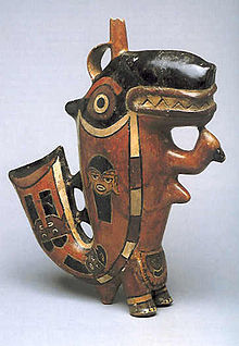
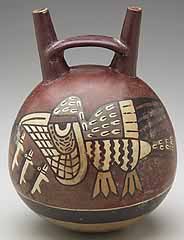
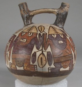
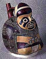
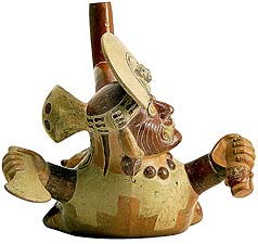
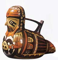
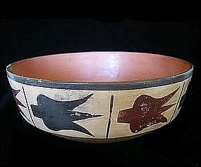
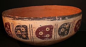
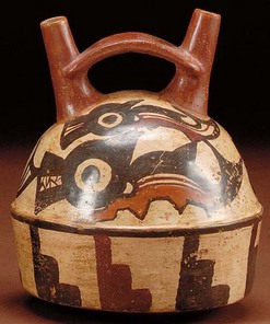
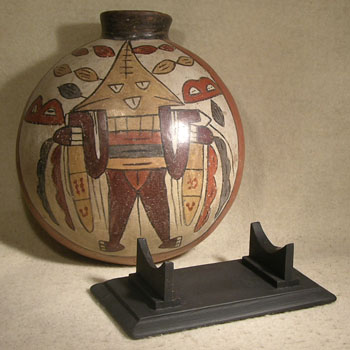
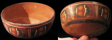
In general, Nazca culture is considered to consist of three stages; Early, Middle, and Late stages, and also the Classic Nazca (approximately A.D. 250-750). One of the most famous and distinctive features of the Nazca culture is the polychrome pottery which has attracted attention because of its technological refinement and the exciting symbolism of its motifs. This pottery culture spreads in the area of the valleys of Chincha, Pisco, Ica, Nazca and Acari.
In the Early stage, these wares did not have much color, but Middle and Late Nazca polychromes are buff or red and are painted in three to eight colors. The most popular choices of color were red, black, white, brown, yellow, gray and violet with an outline in black. Bowls and beakers were common forms, but double-spout and head-and-spout jars are also found. Birds, fish or fruits were commonly drawn on the pottery, and Nazca's religious or mythological features were also used in its design
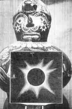
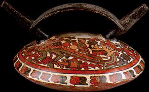
Nazca Figurine depicts a Solar Eclipse and the Eye of Creation
Cahuachi was a major ceremonial center of the Nazca culture and overlooked some of the Nazca lines from 1 CE to about 500 CE. Italian archaeologist Giuseppe Orefici has been excavating the site for the past few decades, bringing a team down every year. The site contains over 40 mounds topped with adobe structures.
The permanent population was quite small, but it was apparently a pilgrimage center that grew greatly in population for major ceremonial events. These events probably involved the Nazca lines and the giant sand dune of Nazca. Support for the pilgrimage theory comes from archaeological evidence of sparse population at Cahuachi and from the Nazca lines themselves which show creatures such as killer whales and monkeys which were not present in the Nazca region. Trade or travel may explain the images. Due to the dry climate the finds are quite rich and include even such ephemeral material as clothing. Looting is the greatest problem facing the site today.
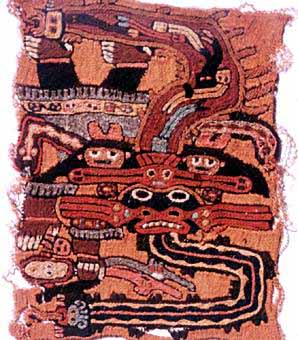
Weaving
Their ancient technique of weaving, that the Nazca people developed, has given an insight into how the lines may have been made, and what they might have been used for more than 1,500 years ago.
Adobe Pyramid at Cahuachi
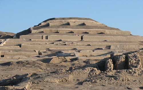
Cahuachi, in Peru, was a major ceremonial center of the Nazca culture and overlooked some of the Nazca lines from 1 CE to about 500 CE. Italian archaeologist Giuseppe Orefici has been excavating the site for the past few decades, bringing a team down every year. The site contains over 40 mounds topped with adobe structures. It has also been studied by Helaine Silverman, who has written a book on Cahuachi.
The permanent population was quite small, but it was apparently a pilgrimage center that grew greatly in population for major ceremonial events. These events probably involved the Nazca lines and the giant sand dune of Nazca. Support for the pilgrimage theory comes from archaeological evidence of sparse population at Cahuachi and from the Nazca lines themselves which show creatures such as orca and monkeys which were not present in the Nazca region. Of course, trade or travel may explain the images. Due to the dry climate the finds are quite rich and include even such ephemeral material as clothing.
Looting is the greatest problem facing the site today. Most of the burial sites surrounding Cahuachi were not known until recently and so present a very tempting target.
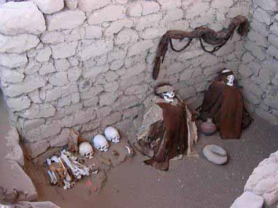
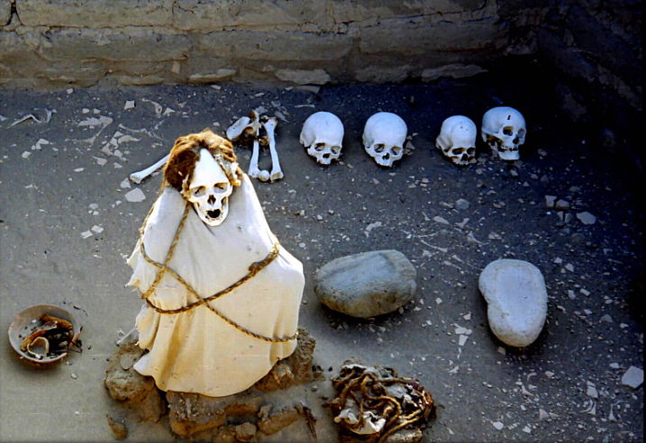
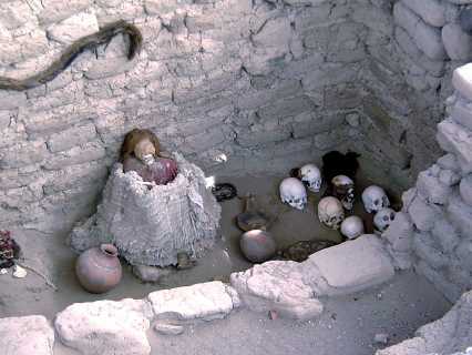
Burial Sites and Rituals
Most of the burial sites surrounding Cahuachi were not known until recently.
The permanent population was quite small, but it was apparently a pilgrimage center that grew greatly in population for major ceremonial events. These events probably involved the Nazca lines and the giant sand dune of Nazca. Support for the pilgrimage theory comes from archaeological evidence of sparse population at Cahuachi and from the Nazca lines themselves which show creatures such as orca and monkeys which were not present in the Nazca region. Of course, trade or travel may explain the images. Due to the dry climate the finds are quite rich and include even such ephemeral material as clothing.
Looting is the greatest problem facing the site today. Most of the burial sites surrounding Cahuachi were not known until recently and so present a very tempting target.
Burial Sites and Rituals
Most of the burial sites surrounding Cahuachi were not known until recently.
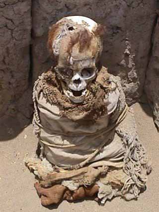
Mummies
Stunningly preserved in the dry soil of the Peruvian desert
are the mummified bodies of the Nazca people themselves.
Stunningly preserved in the dry soil of the Peruvian desert
are the mummified bodies of the Nazca people themselves.
CONDOR
gymnogyps
gymnogyps
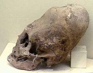
INCA SKULLS
Japanese researchers find new giant picture on Peru's Nazca Plateau
MSNBC - April 21, 2006
A new giant picture on the Nazca Plateau in Peru, which is famous for giant patterns that can be seen from the air, has been discovered by a team of Japanese researchers.
The image is 65 meters long, and appears to be an animal with horns. It is thought to have been drawn as a symbol of hopes for good crops, but there are no similar patterns elsewhere, and the type of the animal remains unclear.
The discovery marks the first time since the 1980s that a picture other than a geometrical pattern has been found on the Nazca Plateau.The picture was found by a team of researchers including Masato Sakai, an associate professor at Yamagata University, after they analyzed images from a U.S. commercial satellite.
They confirmed it was a previously undiscovered picture in a local survey in March this year. It is located south of the Nazca Plateau, and apparently went undiscovered since few tourist planes pass over the area.
Two parts of the picture, that appear to be horns, bear close resemblance to those that appear on earthenware dating from 100 B.C. to A.D. 600, during the time when the Nazca kingdom flourished, and it is thought that they relate to fertility rites.
The research team will use images from the advanced land-observing satellite "Daichi," which was launched by the Japan Aerospace Exploration Agency in January this year, to create a distribution map of images on the earth that can be seen from the air. There is evidence that vehicles had driven in the area, and part of the picture is destroyed. "We want to identify all the images, and work to preserve earth pictures that are gradually being destroyed," Sakai said.
________________________________________
Giant Figures in Peru Desert Pre-date Nazca Lines
Nazca Fisherman
The Epoch Times, May 24, 2005
A group of about 50 drawings of giant figures recently discovered in the hills of Peru's southern coastal desert near the city of Palpa has been said to predate the famous Nazca lines nearby.
Mr. Johny Isla, director of the Andean Institute of Archaeological Studies, said the 'geoglyph' figures appear to have been created by the Paracas communities between 500 and 400 BC, whereas the Nazca culture developed after 50 BC.
Mr. Isla and his partner Dr. Markus Reindel from the Dutch Institute of Archaeology discovered the Paracas figures using aerial photography and land-based surveys. The figures of humans, birds, monkeys and cats vary in size from 10m to 50m across, and are also grouped together in areas up to 60 m to 90 m across.
The Paracas figures were created by removing dark stones in order to expose the lighter surface underneath. Some areas were cleared and others built up with rock, creating figures in high and low relief. With the Nazca lines though, the geoglyphs were only made by clearing low-relief areas. Until recently scientists believed that the figures in the Palpa and Nazca regions were only from the Nazca culture. Mr. Isla says cultural dating and style of the newly found Paracas figures sets them apart.
Mr. Isla told The Epoch Times, "Most of these geoglyphs belong to the Nazca culture but our recent studies demonstrated that there are at least 50 geoglyphs pertaining to the Paracas culture. These new figures are definitely different and older than those of the Nazca culture.
• First, the Paracas figures were drawn on the slopes of the hills, while the Nazca images were drawn in level areas.
• Second, the Paracas figures are smaller and were made in a naturalistic style, while the Nazca figures are bigger and stylized.
• Third, the Paracas figures are mostly arranged in groups, while the Nazca figures are arranged individually.
• Finally, it is important to note that not one of the Paracas figures were repeated in the Nazca iconography."
The Nazca lines and geoglyphs form a unique and magnificent artistic achievement that is unrivalled in its dimensions and diversity anywhere in the prehistoric world. This unique form of land use bears exceptional witness to the culture and beliefs The 'Nazca Lines', as they are commonly known, are the most outstanding group of geoglyphs anywhere in the world. They are also one of the most impenetrable enigmas of archaeology by virtue of their quantity, nature and size, as well as their continuity. The concentration and juxtaposition of the lines, as well as their cultural continuity, demonstrate that this was an important and long-lasting activity.
Intensive study of the geoglyphs and comparison with other manifestations of contemporary art forms suggests that they can be divided into three chronological phases. The first dates from the Chavín period (500-300 BC) and is characterized by the technique of forming figures by piling stones. This was an important time of cultural developments in the Andean region, with strong influence exerted in the Inca region from the north by the Formative Middle Late Culture. The local development known as Paracas represents the second phase (400-200 BC), again strongly influenced from the north. The town of Paracas adapted its culture skilfully to its severe location and achieved a high level of artistic development.
The third phase, which represents the great majority of the geoglyphs, is the Nazca phase proper (200 BC-AD 500). The Nazca culture derived directly from that of Paracas. The Andean towns developed a powerful religious system which produced, along with Moche on the northern coast of Peru, an outstanding culture represented by its handicrafts (notably pottery) and textiles. Most of the geoglyphs of this period are located close to villages of this culture, such as La Quebrada del Frayle, Cahuachi, Palpa and Ingenio, concentrated in Pampa de Jumana.
Two techniques were used to define the geoglyphs. In the earlier Chavín period they were defined in outline, the gravel being removed and piled inwards, so as to leave the figures in slight relief. For the most part, however, the technique used was the removal of the gravel from the figure, providing a solid figure that contrasts with its surroundings.
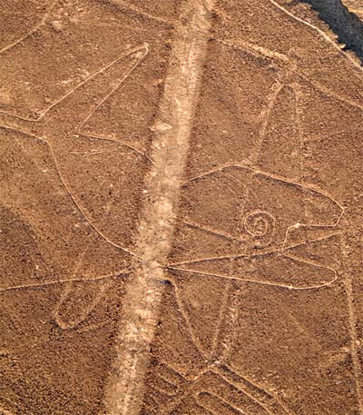
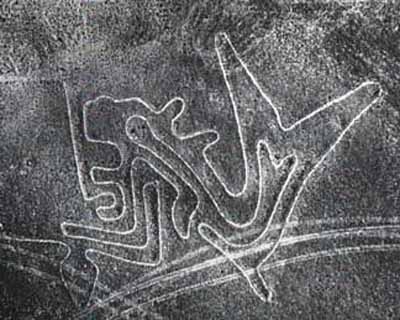
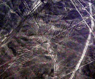
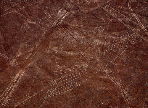
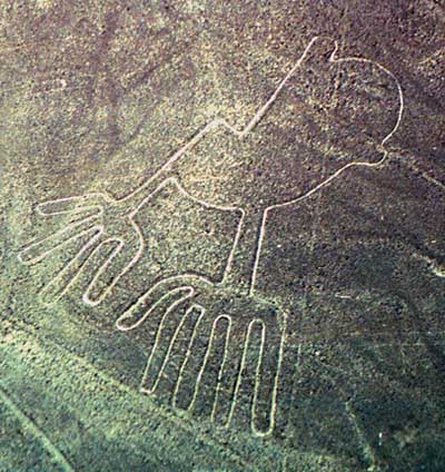
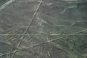
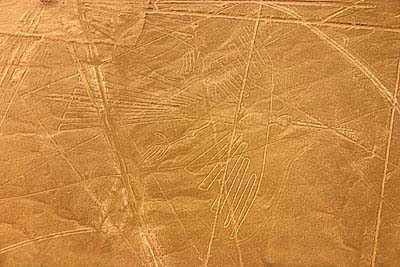
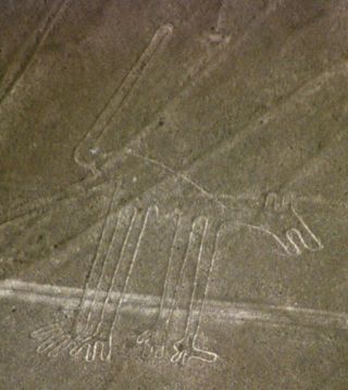
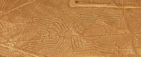
In general terms the geoglyphs fall into two categories: the first group (of which about 70 have been identified) are representational, depicting in schematic form a variety of natural forms. Many of these are animals, birds, insects, and other living creatures: examples include the spider, the monkey, the guanay or guano bird, the lizard, the hummingbird, the killer whales, and the largest of all, the pelican (285 m). Stylistically they can be linked closely with motifs on other representational art of the period, such as pottery and textiles. Other figures represent flowers, plants, and trees, deformed or fantastic figures (strange creature with two human hands, one with only four fingers), and objects of everyday life, such as looms and tupus (ornamental clasps). There are very few anthropomorphic figures, for the most part paralleled by the petroglyphs to be found in the more rocky parts of the region and are considered to be early in date.
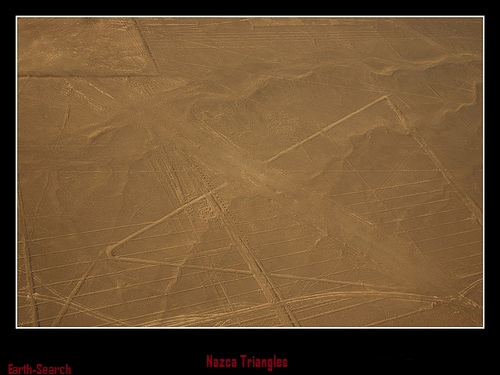
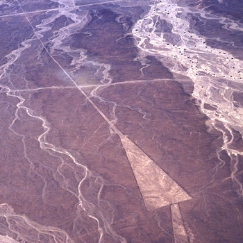
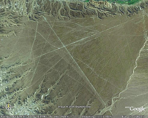
The second group comprises the lines proper. These generally straight lines criss-cross certain parts of the pampas of the region in all directions. Some are several kilometres in length and form designs of many different geometrical figures - triangles, spirals, rectangles, wavy lines, etc. Others radiate from a central promontory or encircle it, as in the cases of the quipus. Yet another group consists of so-called 'tracks', which appear to have been laid out to accommodate large numbers of people.
The figures come in two types: biomorphs and geoglyphs. The biomorphs are some 70 animal and plant figures that include a spider, hummingbird, monkey and a 1,000-foot-long pelican. The biomorphs are grouped together in one area on the plain. Some archaeologists believe they were constructed around 200 BC, about 500 years before the geoglyphs.
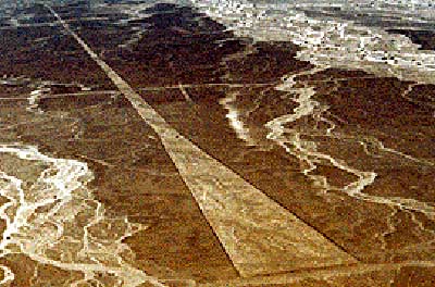
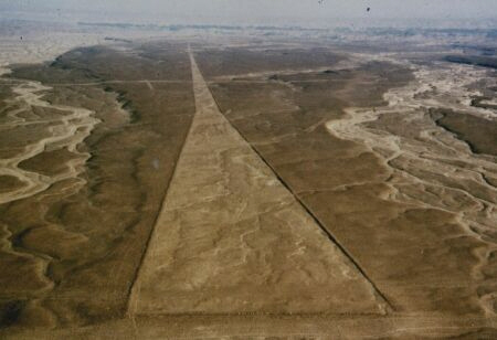
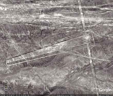
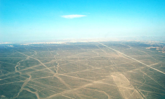
There are about 900 geoglyphs on the plain. Geoglyphs are geometric forms that include straight lines, triangles, spirals, circles and trapezoids. They are enormous in size. The longest straight line goes nine miles across the plain.
What to See
The area of the Peruvian desert in which the Nazca Lines were drawn is called the Pampa Colorada (Red Plain). It is 15 miles wide and runs some 37 miles parallel to the Andes and the Pacific Ocean. The desert is not sandy, but made of dark red surface stones and soil with lighter-colored subsoil beneath. The lines were created by clearing away the darker upper layer to reveal the lighter subsoil.
It seems incredible that such simply-made drawings have survived for so many hundreds of years, and some have seen a mysterious element to this. But there is also a natural explanation: the surface is made of stone, not sand, and the climate of the area is such that there is practically no erosion. The Nazca peoples chose an excellent place for an enduring monument.
The Nazca Lines include straight lines and geometric shapes as well as stylized depictions of animals, humans and plants.
Perhaps the most famous theory of the Nazca Lines is that of Swiss writer Erich von Däniken. In his 1968 book Chariots of the Gods, he suggested that the lines were built by ancient astronauts as a landing field. He identifies the pictures as "signals" and the longer lines as "landing strips."
Giant Figures in Peru Desert Pre-date Nazca Lines
Nazca Fisherman
The Epoch Times, May 24, 2005
A group of about 50 drawings of giant figures recently discovered in the hills of Peru's southern coastal desert near the city of Palpa has been said to predate the famous Nazca lines nearby.
Mr. Johny Isla, director of the Andean Institute of Archaeological Studies, said the 'geoglyph' figures appear to have been created by the Paracas communities between 500 and 400 BC, whereas the Nazca culture developed after 50 BC.
Mr. Isla and his partner Dr. Markus Reindel from the Dutch Institute of Archaeology discovered the Paracas figures using aerial photography and land-based surveys. The figures of humans, birds, monkeys and cats vary in size from 10m to 50m across, and are also grouped together in areas up to 60 m to 90 m across.
The Paracas figures were created by removing dark stones in order to expose the lighter surface underneath. Some areas were cleared and others built up with rock, creating figures in high and low relief. With the Nazca lines though, the geoglyphs were only made by clearing low-relief areas. Until recently scientists believed that the figures in the Palpa and Nazca regions were only from the Nazca culture. Mr. Isla says cultural dating and style of the newly found Paracas figures sets them apart.
Mr. Isla told The Epoch Times, "Most of these geoglyphs belong to the Nazca culture but our recent studies demonstrated that there are at least 50 geoglyphs pertaining to the Paracas culture. These new figures are definitely different and older than those of the Nazca culture.
• First, the Paracas figures were drawn on the slopes of the hills, while the Nazca images were drawn in level areas.
• Second, the Paracas figures are smaller and were made in a naturalistic style, while the Nazca figures are bigger and stylized.
• Third, the Paracas figures are mostly arranged in groups, while the Nazca figures are arranged individually.
• Finally, it is important to note that not one of the Paracas figures were repeated in the Nazca iconography."
The Nazca lines and geoglyphs form a unique and magnificent artistic achievement that is unrivalled in its dimensions and diversity anywhere in the prehistoric world. This unique form of land use bears exceptional witness to the culture and beliefs The 'Nazca Lines', as they are commonly known, are the most outstanding group of geoglyphs anywhere in the world. They are also one of the most impenetrable enigmas of archaeology by virtue of their quantity, nature and size, as well as their continuity. The concentration and juxtaposition of the lines, as well as their cultural continuity, demonstrate that this was an important and long-lasting activity.
Intensive study of the geoglyphs and comparison with other manifestations of contemporary art forms suggests that they can be divided into three chronological phases. The first dates from the Chavín period (500-300 BC) and is characterized by the technique of forming figures by piling stones. This was an important time of cultural developments in the Andean region, with strong influence exerted in the Inca region from the north by the Formative Middle Late Culture. The local development known as Paracas represents the second phase (400-200 BC), again strongly influenced from the north. The town of Paracas adapted its culture skilfully to its severe location and achieved a high level of artistic development.
The third phase, which represents the great majority of the geoglyphs, is the Nazca phase proper (200 BC-AD 500). The Nazca culture derived directly from that of Paracas. The Andean towns developed a powerful religious system which produced, along with Moche on the northern coast of Peru, an outstanding culture represented by its handicrafts (notably pottery) and textiles. Most of the geoglyphs of this period are located close to villages of this culture, such as La Quebrada del Frayle, Cahuachi, Palpa and Ingenio, concentrated in Pampa de Jumana.
Two techniques were used to define the geoglyphs. In the earlier Chavín period they were defined in outline, the gravel being removed and piled inwards, so as to leave the figures in slight relief. For the most part, however, the technique used was the removal of the gravel from the figure, providing a solid figure that contrasts with its surroundings.
In general terms the geoglyphs fall into two categories: the first group (of which about 70 have been identified) are representational, depicting in schematic form a variety of natural forms. Many of these are animals, birds, insects, and other living creatures: examples include the spider, the monkey, the guanay or guano bird, the lizard, the hummingbird, the killer whales, and the largest of all, the pelican (285 m). Stylistically they can be linked closely with motifs on other representational art of the period, such as pottery and textiles. Other figures represent flowers, plants, and trees, deformed or fantastic figures (strange creature with two human hands, one with only four fingers), and objects of everyday life, such as looms and tupus (ornamental clasps). There are very few anthropomorphic figures, for the most part paralleled by the petroglyphs to be found in the more rocky parts of the region and are considered to be early in date.
The second group comprises the lines proper. These generally straight lines criss-cross certain parts of the pampas of the region in all directions. Some are several kilometres in length and form designs of many different geometrical figures - triangles, spirals, rectangles, wavy lines, etc. Others radiate from a central promontory or encircle it, as in the cases of the quipus. Yet another group consists of so-called 'tracks', which appear to have been laid out to accommodate large numbers of people.
The figures come in two types: biomorphs and geoglyphs. The biomorphs are some 70 animal and plant figures that include a spider, hummingbird, monkey and a 1,000-foot-long pelican. The biomorphs are grouped together in one area on the plain. Some archaeologists believe they were constructed around 200 BC, about 500 years before the geoglyphs.
There are about 900 geoglyphs on the plain. Geoglyphs are geometric forms that include straight lines, triangles, spirals, circles and trapezoids. They are enormous in size. The longest straight line goes nine miles across the plain.
What to See
The area of the Peruvian desert in which the Nazca Lines were drawn is called the Pampa Colorada (Red Plain). It is 15 miles wide and runs some 37 miles parallel to the Andes and the Pacific Ocean. The desert is not sandy, but made of dark red surface stones and soil with lighter-colored subsoil beneath. The lines were created by clearing away the darker upper layer to reveal the lighter subsoil.
It seems incredible that such simply-made drawings have survived for so many hundreds of years, and some have seen a mysterious element to this. But there is also a natural explanation: the surface is made of stone, not sand, and the climate of the area is such that there is practically no erosion. The Nazca peoples chose an excellent place for an enduring monument.
The Nazca Lines include straight lines and geometric shapes as well as stylized depictions of animals, humans and plants.
Perhaps the most famous theory of the Nazca Lines is that of Swiss writer Erich von Däniken. In his 1968 book Chariots of the Gods, he suggested that the lines were built by ancient astronauts as a landing field. He identifies the pictures as "signals" and the longer lines as "landing strips."
Double click here to edit this text.
| SITE | |
| NAMES | |
| FLOCATION | |
| F | |
| VFFFAITH | |
| V | |
| VVV | |
| V | |
| VVVV | |
| VVVVVVVVVVVFVVV | |
| FFFV | |
| F |
Lineas de Nazca
Quick Facts
Site Information
Names: Nazca Lines; Nasca Lines; Lineas de Nazca
Location: Peru
Faith: Indigenous
Category: Rock Art
Date: 200 BC-600 AD
Features: Geoglyphs
Status: monument
Visitor Information
Coordinates: 14.701505° S, 75.137043° W (view on Google Maps)
Lodging: View hotels near this location
Public transport: Most visitors hire a local plane to view the lines from the air.
Cost: Varies based on tour or plane ride chosen.
There are many theories associated with the Nazca lines because people did not believe that the ancient Nazca tribe could have had the technology and the equipment to create such precise modern maps and drawings on such a vast piece of land. The Nazca lines include drawings of birds, animals, plants and human figures among many other things. There are hundreds of geometric lines and figures that have also been engraved into the land. The entire area where the Nazca lines and artwork exist is known as the Pampa Colorada or the Red Plain. The area is over 15 miles wide.
The artwork of the Nazca lines has been made by clearing away the dark soil of the upper layer to make way for the inner lighter soil to come through. The Peruvian desert is devoid of sand and contains only dark soil and surface stones all through its area. People who fly over the area of the Nazca lines can clearly make out the intricate lines and geometrical figures along with the other figures that have been engraved into the desert. Creating these lines must have taken the Nazca tribe a hundreds of years. In addition to this, thousands of people must have come together to work on the lines. Researchers could not understand how they managed to create the drawings with such precision and at such a large scale.
One of the popular theories proposed about the lines was that they were made by aliens as a map to track their way around earth. One of the first people to propose this theory was Erich Von Daniken, who said that the entire area of the lines was an alien aircraft field and the drawings were made to help them mark their way around planet earth. However, this theory was dismissed because a lot of the lines do not make any sense and the entire map consisted of confusing drawings of monkeys, birds and lizards which had no significance. In addition to this, no disruption of the soil and artwork around the area proved to show that the area could not have harbored an alien airfield. Some have even said that the geometric line and figures were in fact tracks for spaceships to land and take off on.
The actual reason for the making of these lines is still not clear. Researchers have said that they are related to astronomy and the various line and figures serve as a gigantic astrological map on which the Nazca’s predicted the future. The geoglyphs could in fact be giant effigies of gods and patterns of various constellations in the universe. Researchers are also questioning the way that their figures were created because the Nazca’s did not have any of the modern technology that we possess in the world today.
Swiss author Erich von Däniken suggests the Nazca lines and other complex constructions represent higher technological knowledge than commonly believed to be existing when the glyphs were created. Von Däniken maintains that the Nazca lines in Peru are runways of an ancient airfield that was used by extraterrestrials mistaken by the natives to be their gods.
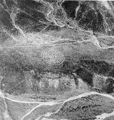
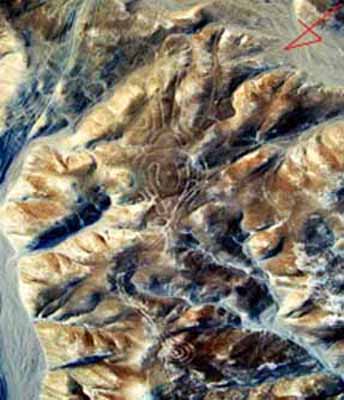
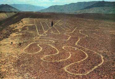
For years people have been making theories about who made the giant figures, how they were made and especially why they were made. A review of these theories follows.Perhaps even more interesting than the figures of animals and the zig-zag lines is one unusual image known as "the mandala." This image is extremely remote and sits atop an arid mountain plateau.
The actual reason for the making of these lines is still not clear. Researchers have said that they are related to astronomy and the various line and figures serve as a gigantic astrological map on which the Nazca’s predicted the future. The geoglyphs could in fact be giant effigies of gods and patterns of various constellations in the universe. Researchers are also questioning the way that their figures were created because the Nazca’s did not have any of the modern technology that we possess in the world today.
Swiss author Erich von Däniken suggests the Nazca lines and other complex constructions represent higher technological knowledge than commonly believed to be existing when the glyphs were created. Von Däniken maintains that the Nazca lines in Peru are runways of an ancient airfield that was used by extraterrestrials mistaken by the natives to be their gods.
For years people have been making theories about who made the giant figures, how they were made and especially why they were made. A review of these theories follows.Perhaps even more interesting than the figures of animals and the zig-zag lines is one unusual image known as "the mandala." This image is extremely remote and sits atop an arid mountain plateau.
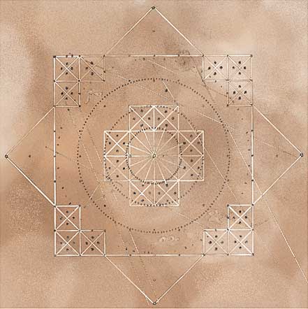
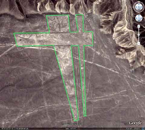
The image appears to have been carved with exceptional precision. A large square measures 180 feet across while an inner circle spans the same diameter. Several smaller squares, about 20 feet wide, appear to have been etched in the landscape along with an assortment of stategically placed holes.
Gilbert de Jong -- A Nazcan Zodiac
Gilbert de Jong actually visited and meticulously surveyed Nazca, measuring and plotting the features with GPS. He was especially interested in the so-called "mandala" figure. This figure, a huge circle inside of a square, appeared to remind him of a zodiac map. This was further supported by the image if a snake-like creature, positioned at one point where de Jong expected to find the symbol for "Aries."
The absense of any other zodiac signs is puzzling. Also, no one has yet figured out the significance of the many holes and pits that are an integral part of the structure.
Gilbert de Jong believes that the interpretation of the many other animal figures is likely to be different representations for constellations by an ancient culture.
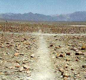
Left: The images are formed by removing randomly scattered stones from the path, exposing the hard packed sand of the desert floor. The paths have been further compacted by footsteps as the ancients appear to have walked along the paths in some ritualistic ceremonies. This is also how the recrangles are made, but on a much larger scale.
Other theories about the Nazca Lines & Figures
Erich von Daniken -- Cargo-Cult
Erich von Daniken's theory is the most famous theory, but it is also the most mis-represented. He never said that the images were made by aliens. Von Daniken believed the line drawings were made by ordinary indians of the region following their encounters with an extraterrestrial race, who used the Nasca plains as a landing strip, or airport, during their expedition to Earth.
It's interesting to see how dated von Daniken's theory is when you realize that he interpreted the trapazoid and rectangular shapes as being caused by repeated blasts from alien rocket engines. He envisioned the debris would be blown away, leaving the clear desert floor. Today, we are likely to see rocket and jet technology as somewhat primitive. UFO's seem to have more advanced antigravity propulsion systems, capable of vertical take off, and leaving no blast effect.
Alan F. Alford -- Negroid Slaves
According to Alford, the Tihuanaco Culture had a large population of Negro slaves that were forced to make these designs under harsh conditions. After a revolution the Negroid population rebelled and destroyed some of the figures, making zigzag and meandering lines to obliterate them. Later the Negroid population migrated North and founded Chavin and the Olmec culture.
One must wonder why, if it was so difficult to make the original designs, these people would invest the time and effort to obliterate and cover them with equally difficult patterns.
Robert Bast -- A memory of the Deluge
Robert Bast from Australia has a very interesting theory. All these animal, plant and human-shaped figures are lying together on the ground, as if they were corpses remaining after some catastrophic flood. So it could be a memorial place of the "big flood." Many cultures in the world have deluge-myths. But one has to question why these animals, of all the known species that exist, were selected.
Robin Edgar -- Solar Eclipses
Robin Edgar from Canada proposes that the Nazca figures were inspired by, and intended to be seen by, the (so-called) "Eye of God" that is manifested during total solar eclipses. An extraordinary series of solar eclipses coincided with the construction of the Nasca lines. Some Lines are aligned with the winter solstice which is often considered as the "death" and "rebirth" of the Sun God.
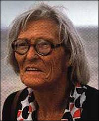
Maria Reiche -- Astronomical Theory
Maria Reiche, the most famous Nazca-Researcher, prefers the astronomical theory. She theorizes that the lines could point in the direction of the rising of important stars or planets and events like sun solstices. Formations like the spider and the monkey could show star constellations like Orion and Ursa Mayor.
Since constellations are constantly changing their position in the sky, because of the precession, Reiche suggests that these alignments could be very old. This would explain why they do not align today and could be a marker of when they were created.
The age of the lines and figures is difficult to determine. They could be extremely old but restored by progressive civilizations over thousands of years. Examination of the desert floor suggests that this may be the case; however, archaeological evidence points to a more recent construction.
Clay pottery and debris has been found along the lines, suggesting food or water was carried to the location either for its construction, ceremonial use, or perhaps both. Radiocarbon dates, based on ceramic and wood remains which were left at the Lines by the Nazcan people has been dated to an era between 300 BC and AD 800. The pottery shards of the style and type of the Nazca culture, further establishing these recent dates as most probable.
Bray Warwick also tried to determine the site's age by examining the stones along the figures. In the heat, the upper exposed side of the stones form a patina of manganese oxide, traces of iron and clay minerals. Below, the stones are covered with mushrooms, lichens and cyanobacterias. Stones in proximity to the lines were used to analyze this organic matter by C-14-Method. Analysis revealed values between 190 B.C. and 600 A.D.
The second piece of evidence is the alleged resemblance of the Nazca geoglyphs to certain features found on Nazcan pottery. This is an important issue because it potentially offers proof that the Nazcans had either designed the images or at least viewed them from the air, since the exact shapes could not otherwise have been known.
National Geographic Society weighs in on the controversy:
In 1968, a study by the National Geographic Society determined that, while some of the Nazca lines did point to the positions of the Sun, Moon and certain stars two thousand years ago, it was no more than could be expected by mere chance. In 1973, Dr. Gerald Hawkins studied 186 lines with a computer program and found that only 20 per cent had any astronomical orientation -- again no more than by pure chance. In 1982, Anthony Aveni obtained similar results. In 1980, Georg Petersen pointed out that Reiche's theory did not explain the different lengths and widths of the lines.
Professor Gerald Hawkins went to Nazca initially to prove the astronomical theory of Maria Reiche. He made a new, more precise survey and analyzed the course of important stars by using new computer software. This software included the star positions for the last 6900 years. After weeks of work they were very disappointed and stated, "We didn't find any astronomical context."
Johan Reinhard has recently noted that the surrounding mountains provided a ready-made and much more effective mechanism for the Nazcans to use as a solar calendar. Native Americans have long used mountain peaks and geometric shapes on rock cliffs to sight the rising Sun and Moon alignments, necessary for determining the best time for planting crops and annual migrations. With all the mountains and peaks in Peru, using these lines for that purpose would have been quite superfluous.
[Maria Reiche, the German mathematician and archaeologist most famous for her research into the enigmatic figures of Nazca, died in 1998 at the age of 95. She is buried in the arid valley she loved so well.]
Jim Woodmann -- The Balloon Theory
Jim Woodmann conducted an experiment making a balloon of fine Peruvian cotton, and a reed basket made by Aymara-Indians. This flying object was called "The Condor." He believed that this method was used by the ancients to direct the construction of the giant figures. He did not explain how such directions would be communicated from the balloon to the ground crew. Hot air from a fire was brought into the balloon and it began to rise uncontrolled. The two pilots narrowly escaped injury before the balloon flew away.
Prof. Anthony Aveni -- Water-Cult
Anthony Aveni compares the Nazca lines with the ceque-lines [right] in Cuzco. Those lines were made in connection with a calendar, water and mountain deities. In this way the Nazca Indians celebrated a water-cult ritual. The figures and lines were used as paths for ceremonial dances.
Michael Coe -- Ceremonial Places
Michael Coe also believes the Lines are sacred paths to walk during specific ceremonial rites. But primary the lines was a offering for elders, heaven- and mountain-deities who spent water for fields.
Georg A. von Breunig -- Sport stadion
Breunig has the very interesting idea that Nazca was used for sprinting to honor especial gods or ritual competitions. The area was a kind of "Olympia" where athleted would be made to run along the various shaped tracks. This theory was also supported by the famous professor Hoimar von Ditfurth.
The Code of Carl Munck: The Ancient Geomatria of Numbers
This theory states that the ancient sites around the world are very precisely positioned on a global coordinate system in relation to the position of the Great Pyramid at Giza. The positions of the sites are given in the geometry of their construction. A very ancient system of numbers was used in the system, which we will call "Gematria." Gematrian" numbers are found in ancient myths and religions, including the Bible. Gematrian numbers were used in systems of weights and measures by ancient peoples, including the Greeks, the Egyptians, the Persians, the Babylonians and the Romans.
The Code system uses mathematical constants, such as pi and the radian. The system also uses conventions that are still in use, such as the 360 degree circle, 60 minute degree, 60 second minute, the base-ten numbering system, the 12-inch foot, and the 5280 foot mile. The ancient Mayans used Gematrian numbers in their very accurate timekeeping. The Nazca Line ground markings "locate themselves" on The Code Matrix System. This theory is part of a new science called Archaeocryptography.
Hawkins and his group went to Nazca to prove the astronomical Theory of Maria Reiche. The made new and precise survey and analyzed the course of important stars by using new computer software. This Software included the star positions of the last 6900 years. After weeks of work they had very disappointed to say: We didn't find any astronomical context.
A similar theory is put forth by John D. Miller. He analyzed different buildings worldwide and found the value of 177 Feet in ancient buildings and old cathedrals. His theories are based on several holy numbers and units, so he believes that there is a deeper importance within these figures.
Dr. Zoltan Zelko -- Map
The Hungarian mathematician Dr. Zoltan Zelko analyzed the Nazca-line-system and compared with other ancient places in Peru. So he found out that Nazca could be a map of a 100 x 800 kilometer including region around the Titicaca-Lake.
Evan Hadingham -- Hallucinogens
Evan Hadingham proposed that the ancient Nazca priests used powerful hallucinogenic concoctions that made them adept at "out of body" experiences. He theorized that the priests, or shamans, were able to transform into spirits and fly above the land. To amuse them or possibly honor them, the giant line art was created.
Prof. Helaine Silverman -- Clan Signs
Helaine Silverman, the co-author of Anthony Aveni suggested that the figures are clan signs of different Indian tribes or families in the region of Nazca. This idea is suppoted by the fact that many clans in North and South America often use an animal, or "totem," to represent their migrations in petroglyphs.
Helaine Silverman, the co-author of Anthony Aveni suggested that the figures are clan signs of different Indian tribes or families in the region of Nazca. This idea is suppoted by the fact that many clans in North and South America often use an animal, or "totem," to represent their migrations in petroglyphs.
Nazca: Maps of the Nazca lines - analysis
Not one single map is the same - it's a scandal how the lines are "sold" in Peru - and there is parallelism with the air tracks of the spacecrafts of the extraterrestrials in spirals and zigzag lines - the line up to Egypt - the connection with the history of creation of Egypt - cities of culture on the equator of former times
Not one single map is the same - it's a scandal how the lines are "sold" in Peru - and there is parallelism with the air tracks of the spacecrafts of the extraterrestrials in spirals and zigzag lines - the line up to Egypt - the connection with the history of creation of Egypt - cities of culture on the equator of former times
A cure stay in Nazca, and there were maps...
When I was in Nazca in August 2009, I did not do much during the first week but I had to recover from a dreadful influence from horrible Lima in winter. Only step by step I saw maps of the Nazca lines, but I did not be interested much because I'm not interested much in stones, but more in humans.
Well, there are lines, and some day I bought a postcard as a souvenir, and this postcard did not seem bad:
Nazca lines of Nazca and Ingenio, and on the other side the airport with the indication of Nazca, with Pueblo Viejo, with the pyramids of Cahuachi, and with the pyramid with column area (Estaquería), with some lines on it heading to the pyramids; photo by J. Alvarado from the edition "www.peruinside.com"; all indications are only in English:
1. Killer Whale
2. Wing
3. Baby Condor
4. Bird
5. Animal
6. Spiral
7. Lizard
8. Tree
9. Hands
10. Spiral
11. Spider
12. Flower
13. Dog
14. Astronaut
15. Triangle
16. Whale
17. Trapazoids
18. Star
19. Pelican
20. Bird
21. Trapazoid
22. Hummingbird
23. Trapezoid
2. Wing
3. Baby Condor
4. Bird
5. Animal
6. Spiral
7. Lizard
8. Tree
9. Hands
10. Spiral
11. Spider
12. Flower
13. Dog
14. Astronaut
15. Triangle
16. Whale
17. Trapazoids
18. Star
19. Pelican
20. Bird
21. Trapazoid
22. Hummingbird
23. Trapezoid
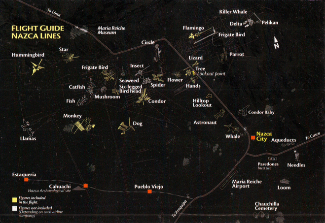
Here is an UNFINISHED list of some Nazca lines Drawings
What do we haver here?
left from Panamericana: Llamas, Hummingbird, Star (also called fan), Catfish, Fish, Monkey, Mushroom, Seaweed, Six-Legged Bird Head, Dog, Condor, Spider, Flower, Tree, Hands, Lookout Point, Hilltop, Astronaut, Whale;
right from Panamericana: Lizard, Flamingo (also called Arum or Heron), Frigate Bird, Parrot, Condor Baby;
and on the other side of Nazca: Loom, Needles.
The prospect corresponds to the map of the National Geographic Institute ("Instituto Geográfico Nacional" in Lima), and by this we can admit that north is upright upside, and the Panamericana is straight as a die in an angle of 45 degrees heading through the Nazca plain ("Pampa de Nazca"). The drawn compass rose is wrong, because north is upright upside.
On this map the drawings of the Astronaut and the Whale are drawn much too close to the Panamericana, and the Llamas at the other side must be turned of 90 degrees.
And the drawn road of Panamericana on the black card seems to be harmonic, but unfortunately this does not correspond with the whole truth consulting google-maps. But at least on the black card the Panamericana is heading straight as a die through the plain as it is in reality:
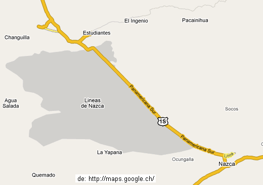
The map of Nazca with the Nasca plain with the real course of the Panamericana (http://maps.google.ch/)
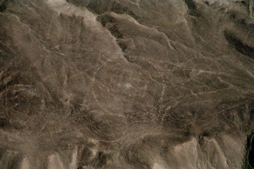
In the google map are missing the geoglyphs. This is a big mistake, but here is a satellite photo of the region. One sees only the lines and the runways well but the drawings not so well (click on the photo):
In the google map are missing the geoglyphs. This is a big mistake, but here is a satellite photo of the region. One sees only the lines and the runways well but the drawings not so well (click on the photo):
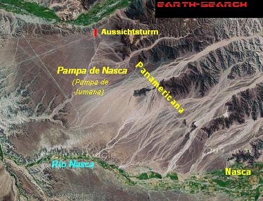
Satellite photo of the Pampa of Nazca (from google digital globe), the upper line is the Panamericana, in the center of the plain is the big cross of lines. The map can also reached here:
So: At the beginning I did not control any map, but I admitted that the maps are real. But there was something interesting with these maps: In a travel office I was given more maps, and not one single map was like the other one. The maps were different:
So: At the beginning I did not control any map, but I admitted that the maps are real. But there was something interesting with these maps: In a travel office I was given more maps, and not one single map was like the other one. The maps were different:
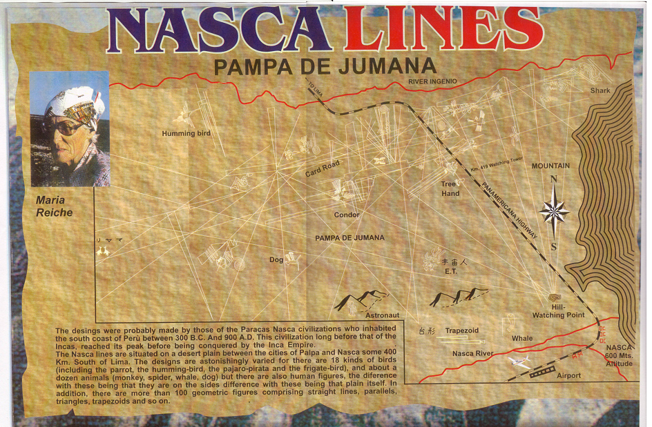
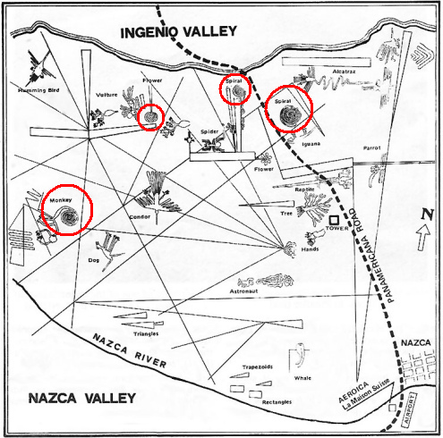
Poster of the Nazca lines and Ingenio lines with the Jumana plain "Pampa de Jumana" with many straight lines and with a portrait of Maria Reiche; indications are in English and some in Japanese, but there are missing many indications, and the natural viewing hill is drawn much too near to Nazca from where are coming lines.
On this poster there are indications only in English or Japanese: There are indicated:
-- Humming bird (better together: Hummingbird)
-- Dog, should be turned by 45 degrees
-- Condor
-- Astronaut (E.T., Priest)
-- Tree
-- Hand, but there are two, so it should be Hands
-- E.T., but the Astronaut is the E.T., and the drawing called E.T. is another drawing
-- Trapezoid
-- Whale
-- Shark.
The prospect corresponds to the map of the National Geographic Institute ("Instituto Geográfico Nacional" in Lima), and by this we can admit that north is upright upside, and the Panamericana is straight as a die in an angle of 45 degrees heading through the Nazca plain ("Pampa de Nazca").
The viewing tower ("mirador metalico") is missing in the map, and aside there should be the viewing hill ("colina mirador"), but this hill is drawn near Nazca which is absolutely wrong.
When the viewing hill ("colina mirador") would be drawn at the right place, so this map would be absolutely valuable because it contains many drawings, left of Panamericana: Llamas, Monkey, Catfish, Dome (also called Six-Legged Bird Head), Bird, Spiral, Spider, Spiral at the Panamericana, Flower, tail of the Lizard; and right of Panamericana the body of the Lizard, another Spiral, Flamingo (also called Arum or Heron), another Bird, Shell, Parrot, and Delta.
It seems strange that the Condor Baby is missing (compare the black card from the beginning), and it seems a pity that this map is appearing under a scientific aspect because the viewing hill is drawn absolutely wrong, and with this also all the lines coming from this hill.
Panamericana is drawn wrong in the same manner as on the black card. Who copied whom can only be guessed, but it seems that official maps of the Military Department are missing in Nazca.
There was another poster yet of the travel office, and this poster was not quite cheap, from the enterprise "FlyEdi", so it is an airline selling flights, and Edi (short form for Eduard) is flying.
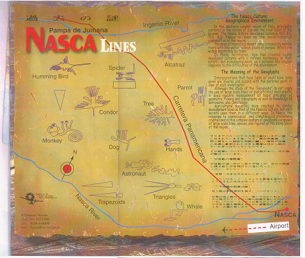
Map with the Nazca lines from the poster of FlyEdi with indications in English or Spanish, with a text in English and Japanese.
What we see here?
-- the prospect seem to be to some degree, and the compass rose seems to be right
Geoglyphs (drawings) left of Panamericana:
-- Humming Bird (better together: Hummingbird) is drawn horizontal, in connection with the compass rose seems to be right
-- Monkey in connection with the compass rose seems to be right
-- Condor in connection with the compass rose seems to be right
-- Trapezoids in connection with the compass rose seem to be wrong, they should be inclined
-- Spider in connection with the compass rose seems to be wrong, it should be inclined
-- Dog in connection with the compass rose seems to be right but the location is absolutely wrong, should be near the monkey
-- Astronaut (or E.T. or Priest) in connection with the compass rose seems to be wrong, should be inclined
-- Tree is absolutely wrong, it's crown is showing to the left but should show to the right, this is a fault of 180 degrees - a scandal
-- Hands in connection with the compass rose seems to be right but should be right next to the Tree
-- Triangles in connection with the compass rose seems to be wrong, should be inclined
Whale in connection with the compass rose seems to be wrong, should be inclined.
Geoglyphs (drawings) right of Panamericana:
-- Alcatraz (Arum, also called Flamingo or Heron) in connection with the compass rose seems to be wrong, should be drawn horizontal
-- Parrot in connection with the compass rose seems to be wrong, should be inclined.
So, it seems that the editor of FlyEdi had turned the compass rose to draw the Panamericana steeper, but the big majority of the drawings were drawn as if the compass rose would point in a straight vertical direction upwards as in the maps before.
And Panamericana in the Nazca plain has no curves, Mr. FlyEdi.
So we have a balance: 9 drawings are drawn in a wrong way, only 4 are drawn well. Why nobody of Peruvian Government is controlling the maps of Peru? Why is there no stricter control how is sold the heredity of Peru with it's Nazca lines to Peruvians and foreign tourists?
But there were even more maps in this travel office. When I compared the maps not one map was the same. The drawings are always drawn differently, be they were with straight lines or without. The Whale one time was like this, another time it was turned by 90 degrees. The Tree one time was like this, another time it was turned by 180 degrees, and the same was with the Spider. The maps indicated the viewing tower and a viewing hill, but the position of the hill always was different, and other maps had no viewing hill. Well, what's that? I thought to myself that there is something wrong with it, and this was the beginning of my little research work. How was it possible that there were so many lines but not one map was the same? There should be something "Peruvian" behind...
I collected more maps about the Nazca lines, and the maps were always different. Here is a yellow map with many tourist indications. There are also the viewing tower ("Mirador metalico") and the viewing hill ("Colina"):
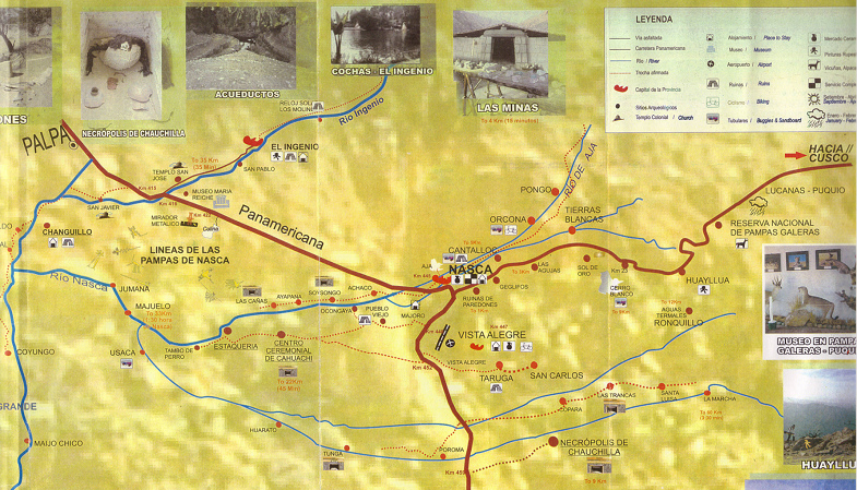
The yellow map of Nazca region with some arbitrary drawings, drawn absolutely wrong, but with many localities, villages, rivers and mountains which are drawn well, with the viewing tower ("Mirador metalico") and with the viewing hill ("Colina"), also with White Mountain ("Cerro Blanco") and with the pyramids of the ceremonial center of today's Cahuachi and with the pyramid with the columns area ("Estaquería"), and with distance indications.
The prospect is turned and north is about 45 degrees top left.
The prospect is turned and north is about 45 degrees top left.
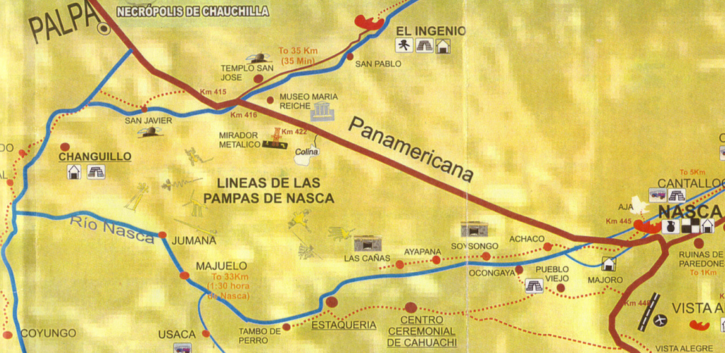
Part of the map with the Nazca lines, an absolute chaos
Well, this cartographer has produced a very good yellow map with locations, rivers and paths, with mountains and viewing points, they are all well drawn, but first the whole map is deformed and the vertical distances are reduced so the Nazca plain is smaller than in reality, and second it seems that the cartographer was very tired at the end of his work and had no motivation any more to draw the few drawings correctly, and by this he drew them according to the random principle, and the result corresponds to the principle: Not one single drawing is right:
-- the Flower should be there where the word "MIRADOR" is
-- the Spider should be turned by 90 degrees and should go in the direction of Jumana
-- the Flamingo should be at the other side of Panamericana aside Ingenio River ("Río Ingenio")
-- the Dog should be turned by appr. 120 degrees
-- the Lizard should be next to the viewing tower and its tail left of Panamericana, the rest right of Panamericana
-- the Bird should be there where the Spider is
-- the Tree should be next to the viewing tower
-- the Pelican should be at the other riverside of Ingenio River ("Río Ingenio").
All is wrong with the Nazca lines? That cannot be true. And Hummingbird is missing! Why nobody of Peruvian Government is controlling the maps of Peru? Why is there no stricter control how is sold the heredity of Peru with it's Nazca lines to Peruvians and foreign tourists?
But pay attention: When I asked at the tourist office of Nazca town hall for a good map of Nazca region, the employees only said that there is none. It seems that neither the local nor the national government are interested how the heredity of Peru with it's Nazca lines is presented to Peruvians and foreigners.
Are there more maps? Yes, but no one is the same: Take in mind: Panamericana is crossing in an absolutely straight way the plain in an angle of 45 degrees. It seems so simple, but there are maps again which cannot show this:
Well, this cartographer has produced a very good yellow map with locations, rivers and paths, with mountains and viewing points, they are all well drawn, but first the whole map is deformed and the vertical distances are reduced so the Nazca plain is smaller than in reality, and second it seems that the cartographer was very tired at the end of his work and had no motivation any more to draw the few drawings correctly, and by this he drew them according to the random principle, and the result corresponds to the principle: Not one single drawing is right:
-- the Flower should be there where the word "MIRADOR" is
-- the Spider should be turned by 90 degrees and should go in the direction of Jumana
-- the Flamingo should be at the other side of Panamericana aside Ingenio River ("Río Ingenio")
-- the Dog should be turned by appr. 120 degrees
-- the Lizard should be next to the viewing tower and its tail left of Panamericana, the rest right of Panamericana
-- the Bird should be there where the Spider is
-- the Tree should be next to the viewing tower
-- the Pelican should be at the other riverside of Ingenio River ("Río Ingenio").
All is wrong with the Nazca lines? That cannot be true. And Hummingbird is missing! Why nobody of Peruvian Government is controlling the maps of Peru? Why is there no stricter control how is sold the heredity of Peru with it's Nazca lines to Peruvians and foreign tourists?
But pay attention: When I asked at the tourist office of Nazca town hall for a good map of Nazca region, the employees only said that there is none. It seems that neither the local nor the national government are interested how the heredity of Peru with it's Nazca lines is presented to Peruvians and foreigners.
Are there more maps? Yes, but no one is the same: Take in mind: Panamericana is crossing in an absolutely straight way the plain in an angle of 45 degrees. It seems so simple, but there are maps again which cannot s
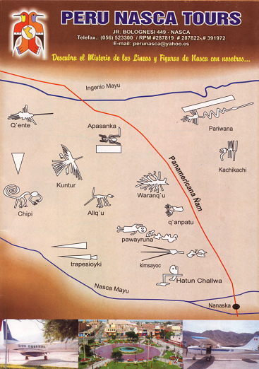
Map of Nazca lines of the travel office "Peru Nasca Tours" with indications in Quechua with Nanaska for Nazca
Let's control:
-- the prospect seems to be inclined as on the map of FlyEdi, and that's why I put aside the inclined compass rose of FlyEdi. This means that again Panamericana is drawn much too steeply and the drawing were not turned with the compass rose...
The geoglyphs (soil drawings) left of Panamericana:
-- Q'ente (Hummingbird) is flying in a horizontal way which is right in connection with the inclined compass rose - well done
-- Kuntur (Condor) in combination with the compass rose should be turned by 120 degrees - wrong
-- Trapesioyki (Trapezoids) in combination with the compass rose should be inclined - wrong
-- Allq'u (Dog) in combination with the compass rose should be turned by 180 degrees - wrong - a scandal
-- Apasanka (Spider) in combination with the compass rose should be inclined - wrong
-- Waranq'u (Tree) in combination with the compass rose should be turned by 180 degrees because the crown is heading to the wrong direction - wrong - a scandal
-- Q'ânpatu (Hands) in combination with the compass rose seem to be right - well done
-- Pawayruna (Astronaut, also E.T. or Priest) in combination with the compass rose should be inclined - wrong
-- Kimsayoc (Triangles) in combination with the compass rose should be inclined - wrong
-- Hatun Challwa (Whale) is drawn well, but in combination with the compass rose should be inclined - wrong
-- Lizard is missing.
Geoglyphs (soil drawings) on the right side of Panamericana:
-- Pariwana (Flamingo, also Arum or Heron) in combination with the compass rose should be drawn in a horizontal way - wrong
-- Kachikachi (Parrot): The drawing is beautiful, but in combination with the compass rose it should be drawn inclined - wrong
-- the Condor Baby is missing.
Let's count: We have 11 wrong geoglyphs, two important ones are missing, and only 2 ones are right. This is the map of a tourist guide. Why Peruvian Government is not controlling better how the Nazca lines are presented and sold?
Well, the case gets really "interesting" now and I informed myself in the Internet. There were found new soil drawings in form of a mandala. Then there were more maps from travel office Peru Nazca Tours yet, and now there were also lines of Palpa and lines of Ingenio. So Nazca is not the only spot, and the whole region is full of drawings. But the drawings on the maps were twisted again, here for example the spider is marching in the wrong direction. This is the map of "Nazca Airlines":
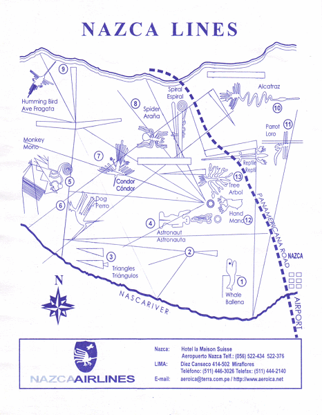
Map with the Nazca Lines with soil drawings and some straight lines from "Nazca Airlines" with indications in English and Spanish. But there are shown only these drawing shown during the flight
Let's control:
-- the prospect seems to be like the map of FlyEdi with a steep Panamericana, and the compass rose on the map would be wrong, so, or the Panamericana should be drawn in an angle of 45 degrees.
Let's say that Panamericana should be drawn in an angle of 45 degrees and the compass rose on the map would be right, so there will be the following result with the geoglyphs:
Geoglyphs (soil drawings) left of Panamericana:
-- Humming Bird (better together: Hummingbird) seems to be right, but the Spanish indication "Ave Fregata" (English: Frigate Bird) is wrong, because this is the Hummingbird (Spanish: Colibrí) and Frigate Bird is at the other side of Panamericana next to Flamingo - wrong
-- Monkey should be turned by 90 degrees - wrong
-- Dog should be turned by 90 degrees to the right - wrong
-- Condor flying in the wrong direction - wrong
-- Trapezoids seem right
-- Spider should be turned by 180 degrees and is marching in the wrong way - a scandal
-- Spiral seems right
-- Astronaut (also E.T., Priest) seems right
-- Reptile is not only a reptile but a Lizard, the drawing is well done
-- Tree seems right
-- Hands are well done
-- Triangles seem right
-- Whale seems right.
Geoglyphs (soil drawings) on the right side of Panamericana:
-- Alcatraz in English is Arum, is called also Flamingo or Heron, is drawn well
-- Parrot seems right
-- Condor Baby is missing.
So, we have 5 wrong drawings, one important is missing, and 10 are right.
And again Panamericana has curves on the map though it's straight as a die in the Pampa. It's not possible.
The map also indicates some important runways, and also some lines which seem to be arbitrary and wrong.
Why nobody of Peruvian Government is controlling the maps of Peru? Why is there no stricter control how is sold the heredity of Peru with it's Nazca lines to Peruvians and foreign tourists?
Another enterprise ("aeroica") offers on the back flights over the Palpa lines. The map is here:
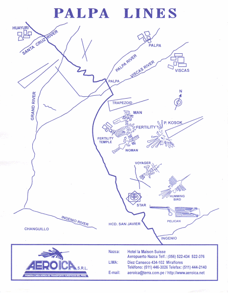
Map with Palpa lines with soil drawings and some straight lines from the airline "aeroica", with indications only in English
Let's control:
-- the prospect seems to be right with north vertically upwards, and there is also a compass rose, but perhaps it is not so right
-- now, the indications are given only in English as if Peruvians will not be interested for this topic
-- Pelican
-- Humming Bird (better: Hummingbird)
-- Star (this is a big mandala), there are missing two little mandalas next to it
-- Voyager
-- P. Kosok (Hummingbird P. Kosok)
-- Fertility Temple with Woman, Fertility and Man
-- Trapezoid.
Long straight lines are missing completely.
One further map with Nazca lines we have here from the airline "Travel Air":
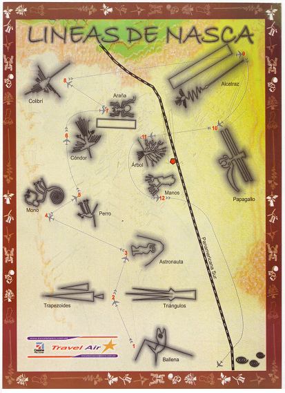
Map of the airline "Travel Air" with the Nazca Lines (only soil drawings), with the viewing tower (big red spot) and with spirals of the aqueducts (downright), from the airline "Travel Air", with indications in Spanish, with the indication of the flight path with a big Boeing or an Airbus with four engines which pretends to be a comfortable flight. But also on this map there are indicated only the soil drawings shown during the flight...
Let's control:
-- the prospect is turned to the right as on the map of FlyEdi, so Panamericana is steeper, and that's why I put the compass rose of FlyEdi aside
With the geoglyphs it's the same case as with the maps before: With some the inclined compass rose was considered, but with the majority not:
-- the following geoglyphs are turned with the compass rose: Manos (Hands), Ballena (Whale)
-- the following geoglyphs are not turned with the compass rose and are drawn in a wrong way: Colibrí (Hummingbird), Araña (Spider), Alcatraz (Arum, also called Flamingo or Heron), Papagallo (Parrot), Cóndor (Condor), Árbol (Tree), Mono (Monkey), Perro (Dog), Astronauta (Astronaut, E.T., Priest), Trapezoides (Trapezoids), Triángulos (Triangles).
-- there are missing the important soil drawings of the Lizard and of the Condor Baby.
So, we have only 2 well done soil drawings, two important ones are missing, and the rest of 11 soil drawings are all drawn in a wrong way. This cannot be true.
At least Panamericana is straight as a die. It seems as if the editors wanted to safe paper by drawing the Panamericana steeper as normal in an angle of 45 degrees...
Finally (downright) there are drawn three spirals. These are spirals of the aqueducts. Here is missing the indication. Also some of the important runways can be seen on the map.
All in all the map is convincing with it's beautiful drawings, but there is missing a compass rose and the adaption of the drawings. And the indication that a Boeing or an Airbus would fly is ridiculous. The passenger will be aware of that entering the sporting aircraft and coming out with dizziness and vomiting...
The same enterprise "Travel Air" offers also flight over the Palpa lines, and again the drawings of the geoglyphs are convincing:
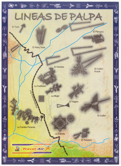
Map of "Travel Air" airline with the Palpa lines with the big mandala, with indications in Spanish
Let's control:
-- the prospect seems to be rather right and north is vertically upwards
Geoglyphs (soil drawings) right of Panamericana:
-- El Tumi (on other maps can be seen the indication that this is a holy sword)
-- El Reloj Solar (Sundial)
-- El Pelícano (Pelican)
-- Temple of Fertility (this indication is missing) for the soil drawings of La Mujer (Woman), La Fertilidad (Fertility) and El Hombre (Man)
-- El Colibrí Kosok (Hummingbird detected by P. Kosok)
-- El Viajero (Voyager)
-- La Estrella (Star, but this is a big mandala with two others next to it though one is drawn and one is missing on the other side)
-- El Colibrí (Hummingbird)
-- and another Pelícano (Pelican).
Geoglyphs (soil drawings) left of Panamericana:
-- la Familia Paracas (Paracas Family).
Long straight lines are missing. But there are other soil drawings without names in forms of squares, trapezoids, spirals (doubled spiral) and triangles.
All in all the map again convinces by their drawings of the geoglyphs.
Another flight over the Nazca lines also contains some Palpa lines, and this map also convinces by it's drawings. Well, it's the same enterprise as before (Travel Air combined with Aero Condor):
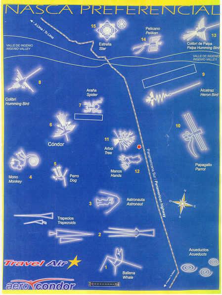
Map of "Travel Air" and "Aero Condor" airlines with the Nazca lines and three drawings of the Palpa lines with the mandala, with indications in Spanish and English, with numeration for the flight whereby there are shown only the drawings which are shown on the flight, at the end with the indication of the aqueducts.
Let's control:
-- the map has got a compass rose, and corresponding to it the Panamericana is drawn steeper as normal, but the big majority of the soil drawings is not turned with it. So all soil drawings are drawn in a wrong way with the exception of the Hands and the Whale. But this cannot be true. The drawings are so well done but almost all is wrong.
The geoglyphs of Palpa are:
-- Colibrí de Palpa (Palpa Hummingbird)
-- Pelícano (Pelican)
-- Estrella (Star, a big mandala with two mandalas aside, but there is missing one of these two ones).
At least the Panamericana is drawn straight as a die and we have the spirals of the aqueducts with it's corresponding indication.
But the important soil drawings of the Lizard and the Condor Baby are missing...
Questions and questions: Spirals and zigzag lines as elements of the flight paths of the spacecrafts of the extraterrestrials
Now I asked myself why Peruvians don't control their culture, why they don't control their editors of the maps. It seems as if they don't control anything. Everybody who wants can publish as he wants, and the great majority is wrong. This should be "freedom"? No, this is all but freedom. Peruvian Government is called to edit maps and to control at least the most important parts of a map about Nazca and Palpa: the position of the geoglyphs, and the compass rose.
But there was another question: Why were there web sites in the Internet with the indication that the Nazca plain (Pampa de Nazca, Pampa de Jumana) was a location for Ufo aircrafts. And when I asked the population in Nazca, every fifth person could tell me a story about an unknown flying object resp. of a spacecraft. There were two persons indicating that they had seen a spacecraft in the sky in spirals, and one person said the spacecraft had made a spiral and then at the end the spacecraft had crossed the whole spiral for it's departure with high speed, and another person said the spacecraft made a spiral and then zigzag lines covering a surface (as it is with the drawing of the monkey or at the other side of Nazca with the figures of the "Needles" or the "Loom"), and at the end the spacecraft had left straight as a die with high speed into the space. I myself had seen aircrafts in 1997 over Zurich over the Lake of Zurich flying with incredible speed in an ample zigzag (like the sawtooth formed zigzag next to the drawing of the "Monkey"), with red and green lights.
And now it will be even more interesting: In these soil drawings of the geoglyphs of the Nazca plain and next to Ingenio and Palpa - in these soil drawings - there are often integrated spirals, and often the drawings are made in zigzag lines where actually is not needed any zigzag line. There are whole surfaces covered by zigzag lines, which is absolutely unnecessary. So, it seems as if the soil drawings of Nazca, Ingenio and Palpa contain elements of the flight paths of the spacecrafts of the extraterrestrials.
Here are some examples:
Geoglyphs (soil drawings) with spirals are
-- in Nazca: Spiral, Monkey with Spiral, Spirals of the aqueducts
-- in Palpa: one Spiral at the Paracas Family, a Doubled Spiral in the sundial and another Doubled Spiral next to it.
Spirals in geoglyphs of Nazca and Palpa
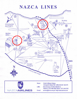
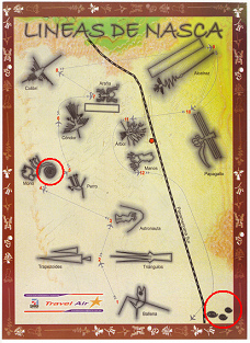
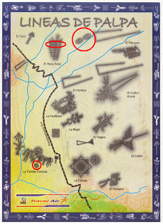
Map of the Nazca lines of the airline "Nazca Airlines" with the indication of two spirals (Monkey, Spiral)
Map of the Nazca lines of the airline "Travel Air" with the indication of spirals (Monkey, Aqueducts)
Map of the Palpa lines of the airline "Travel Air" with the indication of a spiral and two doubled spirals: spiral at Paracas family and two doubled spirals: one in the sundial and one next to it
But now look here: In the Nazca plain there are even four big spirals:
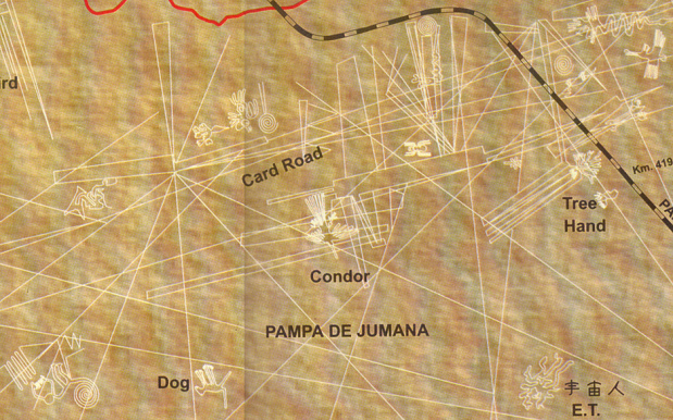
Map with the Nazca lines of the poster with Maria Reiche indicating four big spirals for the Nasca plain

Map with the Nazca lines from only in English, but with 4 spirals: with the Monkey, next to the Flower, and two Spirals for themselves
Perhaps there are even more of them. Ok, the spacecrafts of the extraterrestrials are flying in form of spirals. Is this a coincidence that the geoglyphs in the plain have so many spirals? And the doubled spirals near Palpa are also only a coincidence?
Let's see the zigzag lines now: Nobody will draw a surface in form of zigzag lines only to draw a surface. But the soil drawings of Nazca, Ingenio and Palpa are precisely like this, in zigzag lines, and they cover complete surfaces, or represent wings of feathers or the legs of the spider resp. of the dog or roots of a tree.
Geoglyphs resp. soil drawings of Nazca with zigzag lines covering surfaces or representing feather wings or unnatural legs or roots are: Humming Bird, Monkey, Condor, Alcatraz (Flamingo), Parrot, Spider, Dog, Tree.
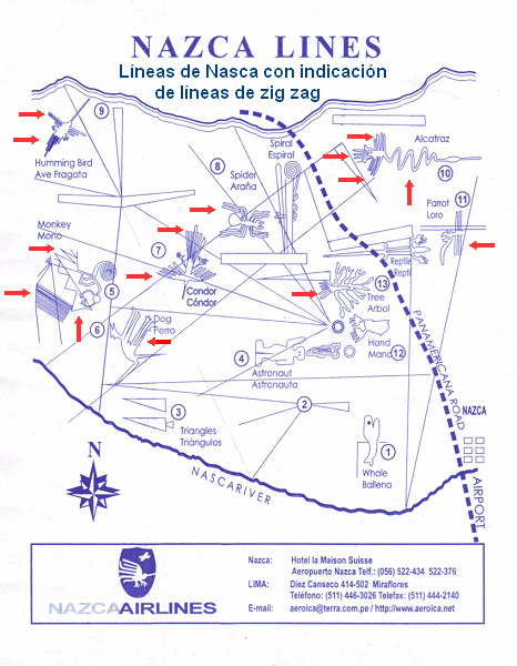
Map with the Nazca lines of the enterprise "Nazca Airlines" with the indication of surface covering zigzag lines with the soil drawings Hummingbird, Monkey, Condor, Alcatraz (Arum, Flamingo, Heron), and Parrot; the Spider's legs are in zigzag lines and much too thick, and the legs of the Dog are in zigzag lines absolutely in an unnatural way, and the roots of the Tree also are in a simple zigzag without any connection to reality.
At the same time also the drawings of the Palpa geoglyphs have a lot of zigzag lines to cover surfaces or to represent the feather wings: at the Sundial (Reloj Solar), at the Pelican (Pelícano), at the Hummingbird of Mr. Kosok (Colibrí Kosok), and at the second Pelican (Pelícano).
At the same time also the drawings of the Palpa geoglyphs have a lot of zigzag lines to cover surfaces or to represent the feather wings: at the Sundial (Reloj Solar), at the Pelican (Pelícano), at the Hummingbird of Mr. Kosok (Colibrí Kosok), and at the second Pelican (Pelícano).
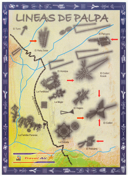
Map with drawings of the Palpa geoglyphs with zigzag lines covering surfaces or representing feather wings: at the Sundial (Reloj Solar), Pelican (Pelícano), Kosok's Hummingbird (Colibrí Kosok), and at the second Pelican (Pelícano).
And on the other side of Nazca there can be found other geoglyphs. Here are shown only two, but both show big surfaces drawn in zigzag lines:
And on the other side of Nazca there can be found other geoglyphs. Here are shown only two, but both show big surfaces drawn in zigzag lines:
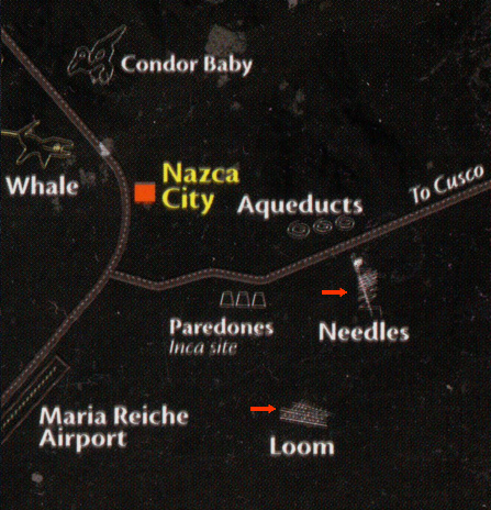
Map of the Nazca lines from peruinside by J. Alvarado with the indication of two geoglyphs on the other side of Nazca with zigzag lines, these are the drawings of the Needles and the Loom.
So, all this should be a coincidence: The spacecrafts of the extraterrestrials are flying in spirals and in zigzag lines and then they leave with great, straight lines often crossing the spiral or the surface in zigzag. Precisely this - in spirals and in zigzag, and with lines crossing the drawings - are OFTEN drawn the geoglyphs. How can this be?
Could the geoglyphs be burnt into the desert soil by the extraterrestrials during their flights? This would be very possible. This would also explain the characters of the lines as Mr. Erich von Daeniken says in his books (lines being haywire but never disappear, lines on wet irrigated soil are disappearing, but when the soil is dry they come up again etc., look in his book "The return of the gods").
Or the humans did imitate the flight paths of the spacecrafts? Also this is possible, but the character of the lines seems to be more "supernatural". All in all in both cases there would be necessary a contact to the extraterrestrials ("aliens").
Or would it be normal to draw a surface in zigzag lines? No.
Add to this there is a mandala with circles and squares, and this is a wonderful gesture of balanced energy which normally is used for meditation in a great plane - or which is from extraterrestrials when it can be found on a slope.
When you ask me the producers of all geoglyphs were extraterrestrials ("aliens"), let's say, in 30 seconds they made one geoglyph. For human work with these lines in a desert without water - for drawing the lines or for celebrating cults on the runways - foot prints are missing, remains of settlements and remains of food (bones, coal, perhaps also graves etc.) are missing (see Daeniken cit.).
Further maps with the lines of Nazca, Ingenio, and Palpa
Let's see further maps in the Internet about Nazca, Ingenio, and Palpa. Again not one map is like the other one, and big mistakes with faults of 180 degrees are repeated...
Maps with the Nazca lines
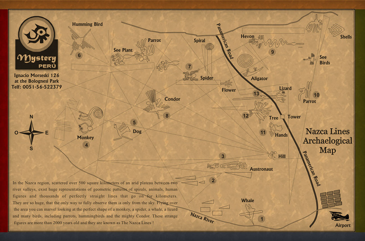
First the compass rose of the map is wrong when Panamericana is that steep. That's why I put the compass rose of FlyEdi aside.
We have the geoglyphs left from Panamericana: Humming Bird (better: Hummingbird), Monkey, Dog, See Plant (better: Sea Plant), Parrot, Condor, Spider, Spiral, Flower, Lizard (the partition is wrong, in reality only the tail is on the left side of Panamericana), Tree, Hands, Hill with a new position between Nazca and the Tower, Astronaut (also E.T. or Priest), Whale;
The geoglyphs right of the Panamericana are: Hevon (this should be a Heron, normally called Flamingo or Arum), Alligator, Parrot, Sea Birds, Shells.
So, some geoglyphs are turned with the Panamericana and correspond with the compass rose of FlyEdi, others not:
-- well drawn are - in connection with the compass rose of FlyEdi: Heron, Tree, Parrot, and Shells
-- drawn in a wrong way - in the "normal" position without adaption to the compass rose of FlyEdi, are: Humming Bird (Hummingbird, Sea Plant, Spiral, Spider, Flower, Condor, Astronaut (E.T., Priest), Trapezoides, Hands
-- absolutely wrong are:
oo Parrot left of Panamericana near the Sea Plant: should be turned 45 degrees to the right
oo Monkey: should be turned 90 degrees to the right
oo Dog: should be turned 45 degrees to the left
oo Whale: should be turned 45 degrees to the left.
Let's count: Well drawn are 4, wrong are 13. Is this possible?
And add to this the Panamericana is not straight as a die. Peruvian Government does not control anything...
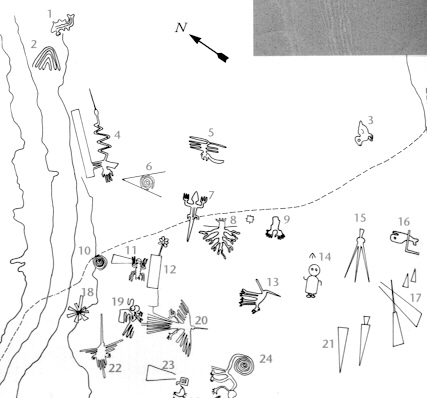
Another map:
Map with the Nazca lines from the website elultimoquecierralapuerta
We see here soil drawings of the Nasca plane. But this is not possible: Also here Panamericana is not straight as a die, and the tree is in the wrong direction, and, and, and...
One more map:
Map with the Nazca lines from "Aero Condor" airline with indications in English or Spanish
Panamericana is that steep as in the maps before, and there exist a compass rose with the right prospect.
Geoglyphs corresponding to the compass rose are: left of Panamericana Humming Bird, Monkey, Dog, Condor, Hands; right of Panamericana: Parrot.
Wrong geoglyphs in "normal position" not turned with the compass rose are: left of Panamericana: Spider, Astronaut (also E.T. or Priest), Trapezoid, Triangles, Whale; right of Panamericana: Alcatraz (Arum, Flamingo, Heron).
Geoglyphs drawn in an absolutely wrong way are: Tree with a wrong prospected crown, must be turned by 180 degrees. This is really embarrassing - an absolute scandal...
There are missing: Spiral left of Panamericana, Lizard, and right of Panamericana is missing the Condor Baby.
We count 5 well done geoglyphs, 6 wrong ones, and 3 important ones are missing.
Panamericana has got many curves. According to the map of Geographic Institute and according to google maps this is wrong.
One more map:
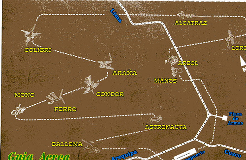
Map with the Nazca lines with the flight path of Chandravan: There are only drawn the geoglyphs
which are shown during the flight
And the Panamericana is this wrong as on the first maps, but at least it is heading straight as a die through the plain...
A dancing astronaut or E.T. on a map
which are shown during the flight
And the Panamericana is this wrong as on the first maps, but at least it is heading straight as a die through the plain...
A dancing astronaut or E.T. on a map
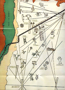
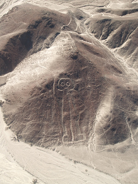
This is the figure of the astronaut / priest / extraterrestrial in reality
Map with the Nazca lines from Kleberhoff's web site with the prospect from the pyramids of Cahuachi, with a good position of the lines' hill, but with a dancing "astronaut" with high arms
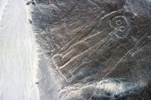
Here one can see very well how the position of the arms of the "Astronaut" is done: one arm up, one arm down
A map with many straight lines with a good position of the lines' hill
A map with many straight lines with a good position of the lines' hill
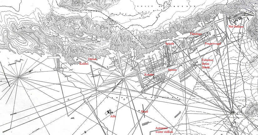
Map with the Nazca lines from Boeckel's website with many straight lines and landform configuration. According to this map of the Geographical Institute also the position of the lines' hill is right.
This map shows a lots of details, and the prospect is right. On the same web site details are presented which - as it seems - come from the map of the Geographical Institute of Lima (Instituto Geográfico Nacional de Lima). Well, but comparing the detailed maps with the real originals one can detect that also on the map of the Institute are missing lines. It's possible that the cartographers of the National Institute don't want to draw the lines "destroying" the drawings?
This map shows a lots of details, and the prospect is right. On the same web site details are presented which - as it seems - come from the map of the Geographical Institute of Lima (Instituto Geográfico Nacional de Lima). Well, but comparing the detailed maps with the real originals one can detect that also on the map of the Institute are missing lines. It's possible that the cartographers of the National Institute don't want to draw the lines "destroying" the drawings?
Details of a map with the Nazca lines compared with the reality
This map shows a lots of details, and the prospect is right. On the same web site details are presented which - as it seems - come from the map of the Geographical Institute of Lima (Instituto Geográfico Nacional de Lima). Well, but comparing the detailed maps with the real originals one can detect that also on the map of the Institute are missing lines. It's possible that the cartographers of the National Institute don't want to draw the lines "destroying" the drawings?
This map shows a lots of details, and the prospect is right. On the same web site details are presented which - as it seems - come from the map of the Geographical Institute of Lima (Instituto Geográfico Nacional de Lima). Well, but comparing the detailed maps with the real originals one can detect that also on the map of the Institute are missing lines. It's possible that the cartographers of the National Institute don't want to draw the lines "destroying" the drawings?
Details of a map with the Nazca lines compared with the reality
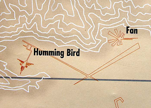
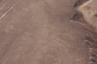
Nazca lines, detail of the map of the Institute with the Hummingbird and the Fan which is also called a Star
The real Hummingbird. On the amplification one can see clearly that there are missing lines on the map of the Institute
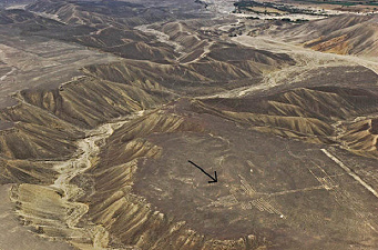
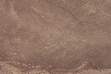
The Hummingbird in it's real surroundings with it's valleys
The real Hummingbird. On the amplification one can see clearly that there are missing lines on the map of the Institute
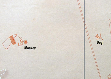
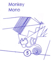
Nazca lines, detail of the map of the Institute with the Monkey and the Dog
Nazca lines, detail of the map of "Nasca Airlines" with the monkey with all it's different zigzag lines
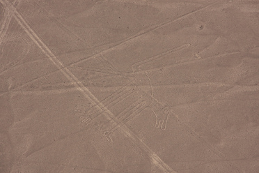
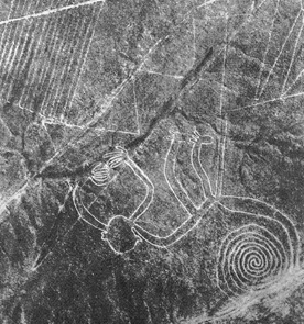
The real geoglyph with the Dog, one can see that the map of the Institute does not correspond with the real lines of the dog, but there are missing lines on the map
The real geoglyph of the Monkey, one sees that the map of the Institute does not at all correspond to the real lines around the monkey, but there are missing two zigzag lines on the map
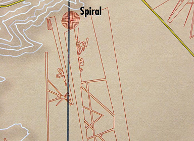
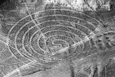
Nazca lines, detail of the map of the Institute with the spiral
The spiral in reality, one sees that there are missing lines on the map of the Institute crossing the spiral
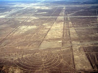
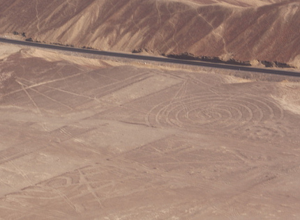
The Spiral in reality with the runways next to it, one sees that on the map of the institute are missing straight lines crossing the spiral
The Spiral in reality, one sees that on the map of the institute there are missing straight lines which even come together
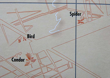
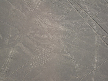
Nazca lines, detail of the map of the institute with the Spider, the Bird and the Condor
The Condor in reality, one sees that on the map of the Institute are missing lines crossing the Condor
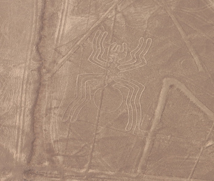
The Spider in reality, one sees that on the map of the institute there are missing lines crossing the Spider, and there are missing lines also next to it
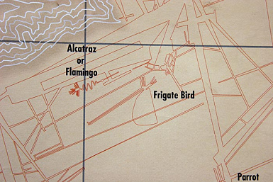
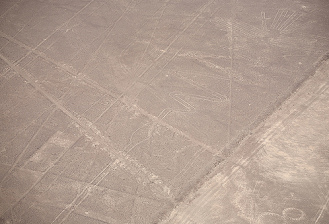
Nazca lines, detail of the map of the Institute with Flamingo or Arum or Heron, and with Frigate Bird
Drawing of Flamingo / Arum / Heron in reality, one can see that on the map of the Institute there are missing lines crossing the drawing
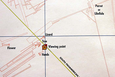
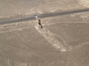
Nazca lines, detail of the map of the Institute with the geoglyphs of the Flower, Lizard, Tree, Hands, and Parrot or Dragonfly (Span.: Libellula), and with the viewing tower
The Tree and the Hands in reality, one can see that on the map of the Institute there are missing straight lines crossing the Tree and the Hands
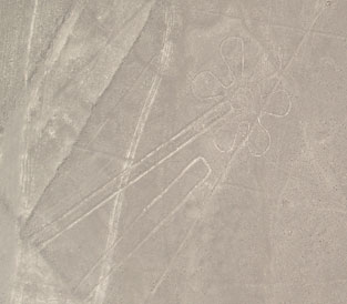

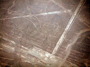
The Flower in reality, on the map of the Institute are missing straight lines crossing the drawing
The Lizard in reality, on the map of the Institute lines crossing the drawing are missing
The Parrot / Dragonfly (Span.: Libellula) in reality, one can see that on the map of the Institute straight lines crossing the beak are missing
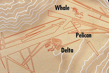
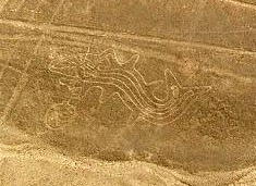
Lines of Ingenio, detail of the map of the Institute with the Whale (basically a Killer Whale), Delta, and Pelican (Ingenio Valley)
The Killer Whale in reality, one can see that on the map of the Institute are missing lines touching the Killer Whale
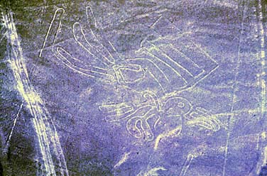
The Pelican in reality, one can see that on the map of the Institute are missing straight lines crossing it's tail
One more map with more drawings: Here one can see the real monkey with all it's zigzag lines, but the Dog seems to be at an absolutely wrong place...
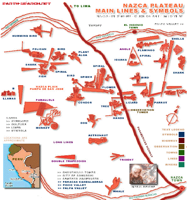
More maps with the Palpa lines
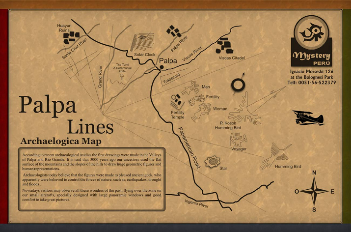
Map with the Palpa lines from the edition mysteryperu with the indications only in English
So, what will be there? Are these drawings also connected with Egypt? This could be true indeed!
Maps with Nazca lines on the other side of Nazca
Also on the other side of Nazca between Vista Alegre and the valley of Taruga River are geoglyphs to find:
So, what will be there? Are these drawings also connected with Egypt? This could be true indeed!
Maps with Nazca lines on the other side of Nazca
Also on the other side of Nazca between Vista Alegre and the valley of Taruga River are geoglyphs to find:
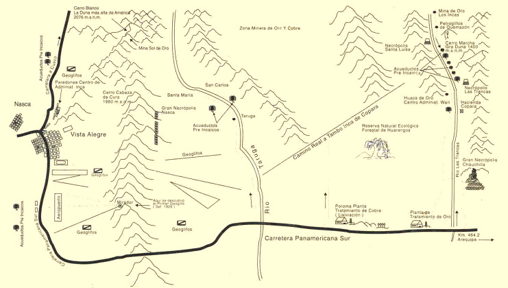
Map with the indication of geoglyphs between Nazca, Vista Alegre, White Mountain ("Cerro Blanco") and the valley of Taruga River ("Río Taruga")
This map only indicates that there are "geoglyphs" but shows no drawings. Where is an official map with all drawings? It seems that this map does not exist...
The two main lines in the Nazca plain
And here is the big cross of lines - the main thing when one sees the region from above (here a satellite photo) - and it seems strange that this cross of lines is never shown on any map:
Satellite photo with the Nazca lines with the big cross of lines. What's with it? (Orientation: Panamericana is top right in black)

Here is a map which has such a cross as it seems. It's this?
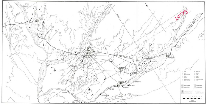
Nazca lines, only with straight lines, from world-mysteries, and turning the map into normal position...
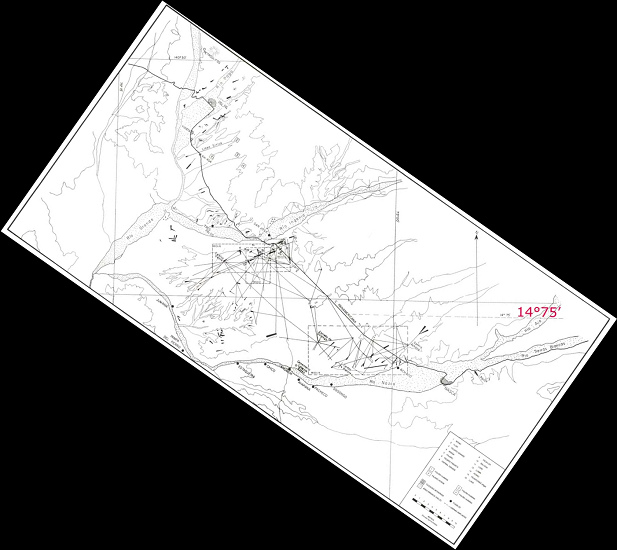
... then the map is coming out like this, but a big cross of lines is not indicated. The cross of lines is becoming a guessing game...
What historians are saying about this big cross of lines which is sparkling in such a strong way on the satellite photo? Some historians say that the big line had been the equator of former times, when North Pole had been on the coast of Pacific Ocean of today's Alaska, and this main line in its elongation comes out directly at the pyramids of Giza:
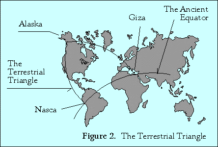
The Nazca main line with it's elongation to Giza in Egypt, as an equator of former times, according to James Bowles [1]
Here one can see the situation absolutely clearly from above:
Here one can see the situation absolutely clearly from above:
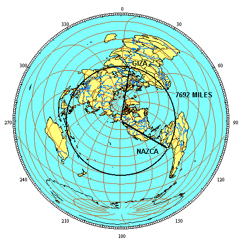
Sight from above on a globe with the big line between Nazca and Giza as equator from former times with the North Pole in today's Alaska on today's Pacific coast, according Jim Allison [2]
Today, with the equator of today, this line between Nazca and Giza is a sinus-shaped waved line, and on this line are further spots with pyramids and old cultures:
Today, with the equator of today, this line between Nazca and Giza is a sinus-shaped waved line, and on this line are further spots with pyramids and old cultures:
The equator of former times with it's connection between Nazca and Giza and many further spots with pyramids and old high cultures, today it's a sinus-shaped waved line [4].
On this line there are most of the holy locations of former times [5], and Nazca is one of these locations:
On this line there are most of the holy locations of former times [5], and Nazca is one of these locations:
Latitude Longitude Distance from the circle Distance from North Pole
Giza
29° 59' N 31° 09' E 0 miles 6.219 miles
Siwa
29° 14' N 25° 31' E 10 miles 6.231 miles
Tassili n'Ajjer
26° 32' N 9° 50' E 0 miles 6.218 miles
Paratoari
12° 48' S 71° 25' W 0 miles 6.219 miles
Ollantaytambo
13° 15' S 72° 16' W 0 miles 6.220 miles
Machupicchu
13° 06' S 72° 35' W 15 miles 6.206 miles
Nazca
14° 42' S 75° 06' W 0 miles 6.221 miles
Easter Island
27° 06' S 109° 20' W 0 miles 6.221 miles
Aneityum Island
20° 10' S 169° 48' E 8 miles 6.230 miles
Preah Vihear
14° 24' N 104° 40' E 25 miles 6.241 miles
Sukhothai
17° 01' N 99° 42' E 5 miles 6.226 miles
Pyay
19° 15' N 95° 05' E 5 miles 6.213 miles
Khajuraho
24° 51' N 79° 56' E 12 miles 6.206 miles
Mohenjo Daro
27° 15' N 68° 17' E 20 miles 6.243 miles
Persepolis
29° 56' N 52° 55' E 5 miles 6.215 miles
Ur
30° 57' N 46° 07' E 40 miles 6.173 miles
Petra
30° 19' N 35° 28' E 6 miles 6.213 miles [5]
Here it's even more clear how the "high civilizations" of former times are on a circle which was equator in former times:
On the equator of former times there is the big majority of centers of "high civilizations" of our forefathers, with it's mythologies and it's pyramids and temples: Nazca, Ollantaytambo, Machu Picchu, Paratoari, Tassili n'Ajjer, Siwa, Giza, Petra, Ur, Persepolis, Mohenjo-Daro, Khajuraho, Pyay, Sukhothai, Preah Vihear, Aneityum Island and Easter Island [5].
How were these civilizations? Some examples:
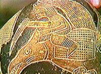
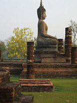
Old civilization of Nazca: a rider on a pterosaurian (pteranodon); stone of stone's museum in Ica
Old civilization of Giza in Egypt, pyramid with sphinx
Old civilization at Sukhothai (today Thailand), Buddha in a temple
Old civilization of Persepolis (today Iran), temple
Old civilization of Pyay, today Myanmar
Old civilization on Easter Island, 638 great statues
But there are missing the old civilizations of the Maya and Mexico. Yes, they should be on the vertical line which is connected with Nasca. That's why the cross of lines at Nasca is that important.

Satellite photo with the lines of Nazca with the big cross of lines. What's with it?
And now there is the question which culture was first. This should be described in the Vedas of India.
Mythology of Egypt with the Nazca drawings
Now some historians indicate that the great line had been the equator of former times, and after a big change of the rotation axis this would not be any more like this. The geoglyphs of Nazca are said to be in direct contact with the Egypt mythology, and the drawings are also said to have other names.
When sacrificially Mrs. Mari Reiche from Dresden was working with the lines she could not read yet the Egypt texts because in these times reading of hieroglyphs was not possible yet. That's why Mrs. Reiche gave names to the soil drawings as they corresponded to their conception of the world. Today - together with the knowledge of the former equator between Nazca and Egypt and with the ability of reading Egypt texts - there are new interpretations:
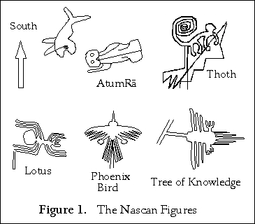
According to indications of the historians these figures also exist in Egypt mythology representing other things and persons, thus Egypt gods, according to James Bowles.
Correcting the positions of the figures a little bit so will come out the following:
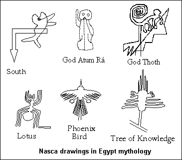
The Nazca drawings existed during Egypt mythology already: the Whale is a compass rose and showing to the south, the astronaut is the main god of Egypt, Atum Rá, the monkey is its ambassador, god Thoth, the spider is converting into a Lotus flower, Condor is Phoenix Bird, and Hummingbird is converting into a Tree of Knowledge [1].
One can admit that all other geoglyphs stand for other gods or things of Egypt mythology. It's not sure what existed first, Egypt mythology - or the Nasca drawings [3] which - according to Sr. James Bowles - have an age of 30,000 years [1].
One can admit that all other geoglyphs stand for other gods or things of Egypt mythology. It's not sure what existed first, Egypt mythology - or the Nasca drawings [3] which - according to Sr. James Bowles - have an age of 30,000 years [1].
Historian James Bowles says in regard to the book of Gerald S. Hawkins "Beyond Stonehenge" that before 30,000 years there happened the same in the Nazca plain as we can read in the Egyptian hieroglyphs on the pyramids of Egypt. This text is put on the walls of the pyramid of Sakkara (Saqqara) in Egypt. These are texts of the mythology as the Egypt philosophs saw them, with a great god Atum Rá as main character.
Historian James Bowles says in regard to the book of Robert Bauval and Adrian Gilbert "The Orion Mystery" that the god Thoth also can exist in form of a monkey.
Historian James Bowles says in regard to the book of Charles H. Hapgood "Earth's Shifting Crust" that 30,000 years before North Pole had been over today's Alaska, and that Nazca and Giza with it's pyramids and with it's sphinx were both on the equator. Triangle Alaska-Nazca-Giza was a holy triangle in former times resp. in ancient history.
Historian James Bowles says that the Nazca drawings are the illustration of the Egypt texts of the Alaska times. In the Egypt texts Atum is also his son Atum Rá,and the drawing of Atum Rá in Nazca as a holy ghost would be the third representation, so there would be a triad. Atum Rá for itself is a hermaphrodite with penis and vagina who can fertilize himself.
Historian James Bowles says that god Thoth is the ambassador of great Creator God Atum Rá. Thoth was the provider of wisdom. Thoth is represented by a monkey with a dog's head (Sinosefalus), or by a flying lemur. the monkey of Nazca represents Thoth, with 9 fingers representing 9 god of On, the men Atum Rá, Shu, G'b, Seth, Osiris, and the four women Tefénet, Nat, Isis and Nephthys. The men are represented by the long tail (symbol for penis), and the women are represented by hands and shoulders.
Add to this historian James Bowles means that the meeting point of the two big lines near the monkey would be the eye of Horus, as a symbol for conversion of hermaphrodite gods into beings like men and women.
Add to this historian James Bowles means that the Egypt texts can be explained by the Nazca geoglyphs where the texts did not make any sense until now.
Conclusion: Mixed culture between Egypt, Nazca and India and more before 30,000 years - the extraterrestrials were the gods [3]
Now one has to know that before 30,000 years the cultures had more contact to the spacecrafts of the extraterrestrials because there was no blockade by "science". And we have the spirals and zigzag lines and the long straight lines crossing the drawings which are strong indications that these drawings have been produced by extraterrestrials. Who would make beautiful soil drawings into the earth and cross the drawing by a fat line at the end? Nobody. So it's really possible that the extraterrestrials made these soil drawings in a kind how the spacecrafts of the extraterrestrials are flying - and starting. When the extraterrestrials were the gods themselves, so these have been the gods themselves. These gods lived in Egypt and in Nazca at the same time because these few 1,000 kilometers was just a stone's throw for them. So one can also imagine who constructed the pyramids of Egypt: the extraterrestrials in half an hour, without light and without noise.
How are made the crop circles? Also by the extraterrestrials without light and without noise. It's the same phenomenon.
We have the Ica stones with an age of 30,000 years, with drawings of riders on pterosaurians (stone museum at Ica, "Museo de piedras", also aviation museum (museo aeronautica) in Lima, see Daeniken, cit), and in Columbia we have models of these airplanes (in gold museum of Bogotá, "Museo de oro", see the photo further below). Add to this this age with it's airplanes also is described in the Vedas of India. So we have the proof for this age before 30,000 years with a trias of Egypt, Nazca / Ica and India, but there will be more proofs on many locations yet.
Add to this geoglyphs with spirals and zigzag lines can be found not only in Nazca, but from North "America" downwards until Chile, see the book of Erich von Daeniken "The return of the gods". Simply nobody is searching, or the military officers know about but don't say anything because they don't know what to do with the "drawings"...
So the extraterrestrials were the gods, and it would be only logic when the humans had prised the extraterrestrials because these knew much more than the humans. Daeniken says in his book "Return of the gods" that Earth is a young planet and humans are really not developed because the development of Earth is in it's infancy yet.
It also would be logic if the extraterrestrials had built the giant pyramids, first in Egypt, and then on other locations, so, on the former equator line. Only with Cahuachi near Nazca I have my doubts because these pyramids of Cahuachi are built of clay bricks what is well possible by humans. Perhaps the whole was like this: The spacecraft came down and the god presented himself and gave help to the humans. By this he was prised by the humans and the god said that they had to prise him with the pyramids which he built for them. Jewry, Church and Islam interrupted the connection to the extraterrestrials with the claim that there would be only "one god", and materialist culture destroyed all the rest of the energy which is going with the wave of universe [3].
Perspective: Precise maps and flights in the Nazca region with hot-air balloons or zeppelins - or with airplanes from Bogotá
Considering that all connections between the geoglyphs and the straight lines are important, so there should be maps of Nazca, Ingenio and Palpa which are absolutely precise, and the world is called to look for more geoglyphs in the whole world.
Now everybody can research for more geoglyphs and spacecrafts of the extraterrestrials and Egypt. The claim is the following:
-- generally the state of Peru is called to produce good and correct maps, and to control the editors if the maps have faults (basic lines in good and correct shape and a well drawn compass rose), because the geoglyphs with it's drawings and with it's straight lines contain more than only a children's drawing in the first primary school as it seems, and when you ask me, it's important to draw ALL geoglyphs and not only the some "spectacular" geoglyphs which correspond to the main stream of the today's capitalist world and which are the content of the today's standard tourism flights
-- above all the big cross of lines of Nazca should not be forgotten in the maps !!!
-- it's recommended to install flights over the Nazca and Palpa lines in hot-air balloons or in zeppelins and not any more in sporting aircrafts which cause dizziness and vomiting...

It would be more comfortable to have flights in hot-air balloons over the Nazca or Palpa lines

Or it would be even more comfortable to have flights over the Nazca, Ingenio and Palpa lines with a zeppelin.
According to historians the old cultures of ancient history in South "America" were flying with these airplanes (here are the models of Gold Museum of Bogotá)
Nazca Lines
Tue, 15th November, 2011
These are the incredible Nazca Lines.
Please Sign Guestbook
I Believe that this is a very significant find, HOW could such a primitive culture create such highly intelligent design? The Mathematical precision is flawless. You can only see this from the sky HOW WAS THEY DOING THIS? Could this be Alien intervention? I think so.